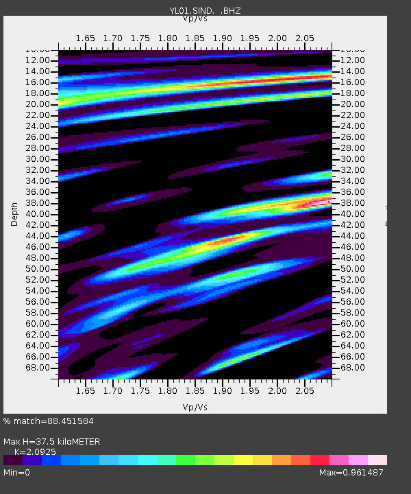
SIND YL.SIND - Earthquake Result Viewer
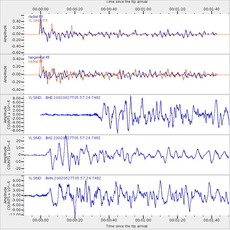
Earthquake location: Sunda Strait, Indonesia
Earthquake latitude/longitude: -7.0/104.2
Earthquake time(UTC): 2002/06/27 (178) 05:50:35 GMT
Earthquake Depth: 11 km
Earthquake Magnitude: 6.0 MB, 6.9 MS, 6.6 MW, 6.5 MW
Earthquake Catalog/Contributor: WHDF/NEIC
Network: YL Himalayan Nepal Tibet Experiment
Station: SIND YL.SIND
Lat/Lon: 27.21 N/85.91 E
Elevation: 465 m
Distance: 38.3 deg
Az: 333.225 deg
Baz: 149.857 deg
Ray Param: 0.07563705
Estimated Moho Depth: 37.5 km
Estimated Crust Vp/Vs: 2.09
Assumed Crust Vp: 6.142 km/s
Estimated Crust Vs: 2.935 km/s
Estimated Crust Poisson's Ratio: 0.35
Radial Match: 88.451584 %
Radial Bump: 400
Transverse Match: 85.16458 %
Transverse Bump: 400
SOD ConfigId: 16844
Insert Time: 2010-02-26 16:11:49.843 +0000
GWidth: 2.5
Max Bumps: 400
Tol: 0.001

Signal To Noise

ChannelStoNSTALTA
YL:SIND: :BHZ:20020627T05:57:24.748Z13.1355641.9499353E-61.4844703E-7
YL:SIND: :BHN:20020627T05:57:24.748Z4.3280357.404989E-71.7109355E-7
YL:SIND: :BHE:20020627T05:57:24.748Z3.74242456.344049E-71.695171E-7
Arrivals
Ps7.1 SECOND
PpPs18 SECOND
PsPs/PpSs25 SECOND