You are here: Home > Network List > OX - North-East Italy Seismic Network Stations List
> Station DRE Drenchia > Earthquake Result Viewer
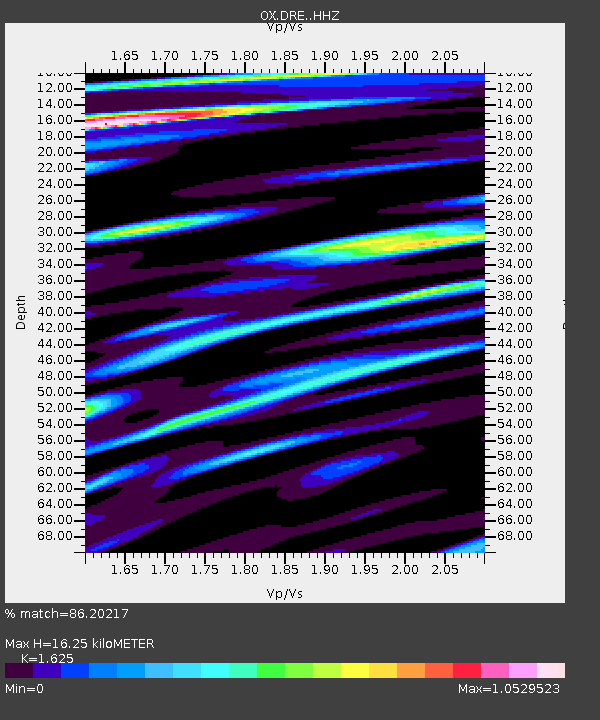
DRE Drenchia - Earthquake Result Viewer
| Earthquake location: |
Northern Peru |
| Earthquake latitude/longitude: |
-4.5/-76.7 |
| Earthquake time(UTC): |
2021/11/28 (332) 10:52:14 GMT |
| Earthquake Depth: |
99 km |
| Earthquake Magnitude: |
7.4 Mi |
| Earthquake Catalog/Contributor: |
NEIC PDE/at |
|
| Network: |
OX North-East Italy Seismic Network |
| Station: |
DRE Drenchia |
| Lat/Lon: |
46.17 N/13.65 E |
| Elevation: |
810 m |
|
| Distance: |
93.5 deg |
| Az: |
44.119 deg |
| Baz: |
267.138 deg |
| Ray Param: |
0.04120783 |
| Estimated Moho Depth: |
16.25 km |
| Estimated Crust Vp/Vs: |
1.62 |
| Assumed Crust Vp: |
6.35 km/s |
| Estimated Crust Vs: |
3.908 km/s |
| Estimated Crust Poisson's Ratio: |
0.20 |
|
| Radial Match: |
86.20217 % |
| Radial Bump: |
400 |
| Transverse Match: |
67.67833 % |
| Transverse Bump: |
400 |
| SOD ConfigId: |
26694651 |
| Insert Time: |
2021-12-12 11:24:01.792 +0000 |
| GWidth: |
2.5 |
| Max Bumps: |
400 |
| Tol: |
0.001 |
|

Signal To Noise
| Channel | StoN | STA | LTA |
| OX:DRE: :HHZ:20211128T11:04:47.090027Z | 8.007279 | 2.1102746E-6 | 2.635445E-7 |
| OX:DRE: :HHN:20211128T11:04:47.090027Z | 1.6581376 | 2.9921276E-7 | 1.8045111E-7 |
| OX:DRE: :HHE:20211128T11:04:47.090027Z | 2.3123064 | 7.093398E-7 | 3.0676722E-7 |
| Arrivals |
| Ps | 1.6 SECOND |
| PpPs | 6.6 SECOND |
| PsPs/PpSs | 8.2 SECOND |


