You are here: Home > Network List > TA - USArray Transportable Network (new EarthScope stations) Stations List
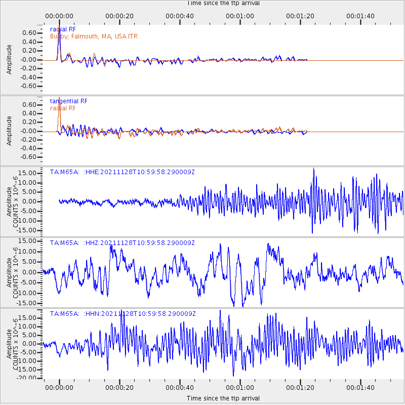
> Station M65A Busby, Falmouth, MA, USA > Earthquake Result Viewer
M65A Busby, Falmouth, MA, USA - Earthquake Result Viewer
| Earthquake location: |
Northern Peru |
| Earthquake latitude/longitude: |
-4.5/-76.7 |
| Earthquake time(UTC): |
2021/11/28 (332) 10:52:14 GMT |
| Earthquake Depth: |
99 km |
| Earthquake Magnitude: |
7.4 Mi |
| Earthquake Catalog/Contributor: |
NEIC PDE/at |
|
| Network: |
TA USArray Transportable Network (new EarthScope stations) |
| Station: |
M65A Busby, Falmouth, MA, USA |
| Lat/Lon: |
41.56 N/70.65 W |
| Elevation: |
22 m |
|
| Distance: |
46.2 deg |
| Az: |
6.298 deg |
| Baz: |
188.38 deg |
| Ray Param: |
0.070487656 |
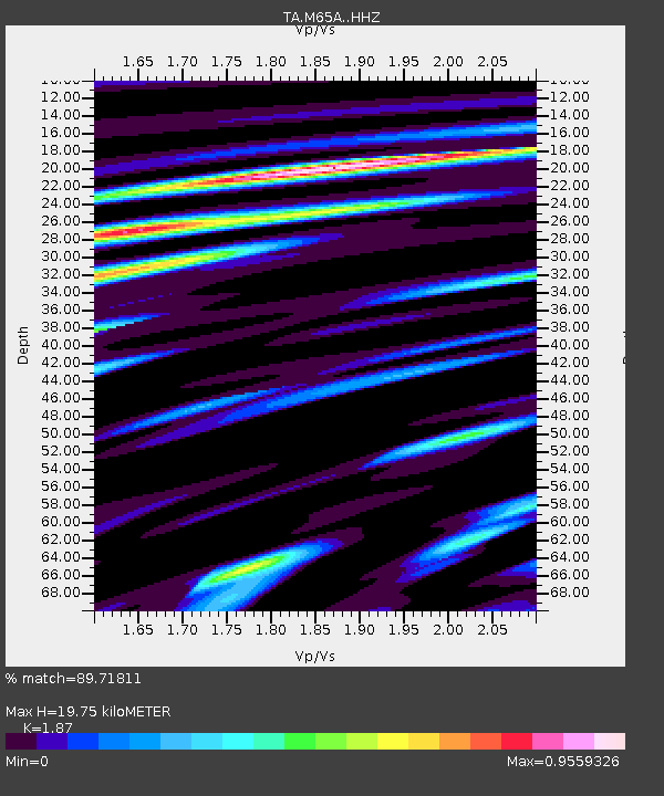
| Estimated Moho Depth: |
19.75 km |
| Estimated Crust Vp/Vs: |
1.87 |
| Assumed Crust Vp: |
6.472 km/s |
| Estimated Crust Vs: |
3.461 km/s |
| Estimated Crust Poisson's Ratio: |
0.30 |
|
| Radial Match: |
89.71811 % |
| Radial Bump: |
400 |
| Transverse Match: |
56.99351 % |
| Transverse Bump: |
400 |
| SOD ConfigId: |
26694651 |
| Insert Time: |
2021-12-12 11:26:15.879 +0000 |
| GWidth: |
2.5 |
| Max Bumps: |
400 |
| Tol: |
0.001 |
|
Signal To Noise
| Channel | StoN | STA | LTA |
| TA:M65A: :HHZ:20211128T10:59:58.290009Z | 5.6946287 | 5.2216046E-6 | 9.1693505E-7 |
| TA:M65A: :HHN:20211128T10:59:58.290009Z | 3.6488712 | 3.5021994E-6 | 9.598035E-7 |
| TA:M65A: :HHE:20211128T10:59:58.290009Z | 1.5064721 | 1.2878024E-6 | 8.548465E-7 |
| Arrivals |
| Ps | 2.8 SECOND |
| PpPs | 8.2 SECOND |
| PsPs/PpSs | 11 SECOND |


