You are here: Home > Network List > TX - Texas Seismological Network Stations List
> Station 435B Jarrell, TX, USA > Earthquake Result Viewer
435B Jarrell, TX, USA - Earthquake Result Viewer
| Earthquake location: |
Northern Peru |
| Earthquake latitude/longitude: |
-4.5/-76.7 |
| Earthquake time(UTC): |
2021/11/28 (332) 10:52:14 GMT |
| Earthquake Depth: |
99 km |
| Earthquake Magnitude: |
7.4 Mi |
| Earthquake Catalog/Contributor: |
NEIC PDE/at |
|
| Network: |
TX Texas Seismological Network |
| Station: |
435B Jarrell, TX, USA |
| Lat/Lon: |
30.78 N/97.58 W |
| Elevation: |
248 m |
|
| Distance: |
40.4 deg |
| Az: |
331.724 deg |
| Baz: |
146.717 deg |
| Ray Param: |
0.07411358 |
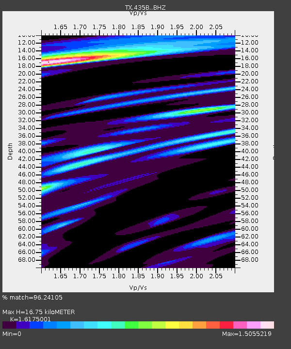
| Estimated Moho Depth: |
16.75 km |
| Estimated Crust Vp/Vs: |
1.62 |
| Assumed Crust Vp: |
6.347 km/s |
| Estimated Crust Vs: |
3.924 km/s |
| Estimated Crust Poisson's Ratio: |
0.19 |
|
| Radial Match: |
96.24105 % |
| Radial Bump: |
350 |
| Transverse Match: |
92.14337 % |
| Transverse Bump: |
400 |
| SOD ConfigId: |
26694651 |
| Insert Time: |
2021-12-12 11:26:30.073 +0000 |
| GWidth: |
2.5 |
| Max Bumps: |
400 |
| Tol: |
0.001 |
|

Signal To Noise
| Channel | StoN | STA | LTA |
| TX:435B: :BHZ:20211128T10:59:11.674988Z | 23.154604 | 6.588383E-6 | 2.8453877E-7 |
| TX:435B: :BHN:20211128T10:59:11.674988Z | 14.01842 | 3.0416943E-6 | 2.1697839E-7 |
| TX:435B: :BHE:20211128T10:59:11.674988Z | 10.0075445 | 1.8543873E-6 | 1.8529893E-7 |
| Arrivals |
| Ps | 1.8 SECOND |
| PpPs | 6.4 SECOND |
| PsPs/PpSs | 8.2 SECOND |


