You are here: Home > Network List > TX - Texas Seismological Network Stations List
> Station FW01 Dallas Executive Airport > Earthquake Result Viewer
FW01 Dallas Executive Airport - Earthquake Result Viewer
| Earthquake location: |
Northern Peru |
| Earthquake latitude/longitude: |
-4.5/-76.7 |
| Earthquake time(UTC): |
2021/11/28 (332) 10:52:14 GMT |
| Earthquake Depth: |
99 km |
| Earthquake Magnitude: |
7.4 Mi |
| Earthquake Catalog/Contributor: |
NEIC PDE/at |
|
| Network: |
TX Texas Seismological Network |
| Station: |
FW01 Dallas Executive Airport |
| Lat/Lon: |
32.68 N/96.88 W |
| Elevation: |
203 m |
|
| Distance: |
41.6 deg |
| Az: |
334.041 deg |
| Baz: |
148.836 deg |
| Ray Param: |
0.0733234 |
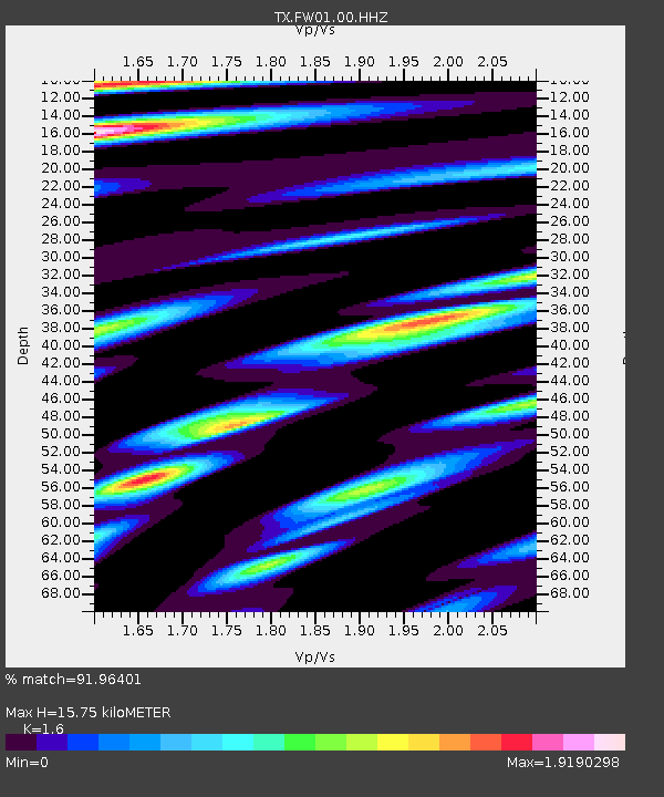
| Estimated Moho Depth: |
15.75 km |
| Estimated Crust Vp/Vs: |
1.60 |
| Assumed Crust Vp: |
6.38 km/s |
| Estimated Crust Vs: |
3.988 km/s |
| Estimated Crust Poisson's Ratio: |
0.18 |
|
| Radial Match: |
91.96401 % |
| Radial Bump: |
400 |
| Transverse Match: |
83.65085 % |
| Transverse Bump: |
400 |
| SOD ConfigId: |
26694651 |
| Insert Time: |
2021-12-12 11:26:45.788 +0000 |
| GWidth: |
2.5 |
| Max Bumps: |
400 |
| Tol: |
0.001 |
|

Signal To Noise
| Channel | StoN | STA | LTA |
| TX:FW01:00:HHZ:20211128T10:59:22.170013Z | 25.187267 | 9.277264E-6 | 3.6833154E-7 |
| TX:FW01:00:HH1:20211128T10:59:22.170013Z | 6.439001 | 2.7763042E-6 | 4.3117004E-7 |
| TX:FW01:00:HH2:20211128T10:59:22.170013Z | 3.9778957 | 2.285008E-6 | 5.744263E-7 |
| Arrivals |
| Ps | 1.6 SECOND |
| PpPs | 6.0 SECOND |
| PsPs/PpSs | 7.6 SECOND |


