You are here: Home > Network List > TX - Texas Seismological Network Stations List
> Station FW02 City of Haslet > Earthquake Result Viewer
FW02 City of Haslet - Earthquake Result Viewer
| Earthquake location: |
Northern Peru |
| Earthquake latitude/longitude: |
-4.5/-76.7 |
| Earthquake time(UTC): |
2021/11/28 (332) 10:52:14 GMT |
| Earthquake Depth: |
99 km |
| Earthquake Magnitude: |
7.4 Mi |
| Earthquake Catalog/Contributor: |
NEIC PDE/at |
|
| Network: |
TX Texas Seismological Network |
| Station: |
FW02 City of Haslet |
| Lat/Lon: |
32.95 N/97.34 W |
| Elevation: |
226 m |
|
| Distance: |
42.1 deg |
| Az: |
333.748 deg |
| Baz: |
148.368 deg |
| Ray Param: |
0.07306874 |
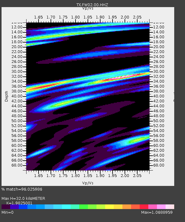
| Estimated Moho Depth: |
32.0 km |
| Estimated Crust Vp/Vs: |
1.98 |
| Assumed Crust Vp: |
6.38 km/s |
| Estimated Crust Vs: |
3.218 km/s |
| Estimated Crust Poisson's Ratio: |
0.33 |
|
| Radial Match: |
96.025986 % |
| Radial Bump: |
400 |
| Transverse Match: |
85.51076 % |
| Transverse Bump: |
400 |
| SOD ConfigId: |
26694651 |
| Insert Time: |
2021-12-12 11:26:48.157 +0000 |
| GWidth: |
2.5 |
| Max Bumps: |
400 |
| Tol: |
0.001 |
|

Signal To Noise
| Channel | StoN | STA | LTA |
| TX:FW02:00:HHZ:20211128T10:59:25.660004Z | 70.575485 | 9.21156E-6 | 1.3052068E-7 |
| TX:FW02:00:HH1:20211128T10:59:25.660004Z | 7.3594704 | 3.1281738E-6 | 4.250542E-7 |
| TX:FW02:00:HH2:20211128T10:59:25.660004Z | 4.39092 | 1.4989762E-6 | 3.4138088E-7 |
| Arrivals |
| Ps | 5.2 SECOND |
| PpPs | 14 SECOND |
| PsPs/PpSs | 19 SECOND |


