You are here: Home > Network List > TX - Texas Seismological Network Stations List
> Station FW05 UT at Dallas > Earthquake Result Viewer
FW05 UT at Dallas - Earthquake Result Viewer
| Earthquake location: |
Northern Peru |
| Earthquake latitude/longitude: |
-4.5/-76.7 |
| Earthquake time(UTC): |
2021/11/28 (332) 10:52:14 GMT |
| Earthquake Depth: |
99 km |
| Earthquake Magnitude: |
7.4 Mi |
| Earthquake Catalog/Contributor: |
NEIC PDE/at |
|
| Network: |
TX Texas Seismological Network |
| Station: |
FW05 UT at Dallas |
| Lat/Lon: |
32.99 N/96.75 W |
| Elevation: |
207 m |
|
| Distance: |
41.9 deg |
| Az: |
334.418 deg |
| Baz: |
149.188 deg |
| Ray Param: |
0.07320684 |
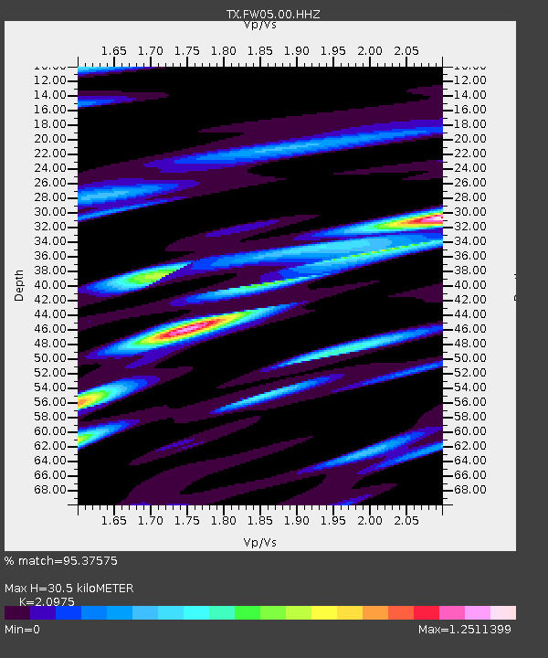
| Estimated Moho Depth: |
30.5 km |
| Estimated Crust Vp/Vs: |
2.10 |
| Assumed Crust Vp: |
6.38 km/s |
| Estimated Crust Vs: |
3.042 km/s |
| Estimated Crust Poisson's Ratio: |
0.35 |
|
| Radial Match: |
95.37575 % |
| Radial Bump: |
350 |
| Transverse Match: |
78.14843 % |
| Transverse Bump: |
381 |
| SOD ConfigId: |
26694651 |
| Insert Time: |
2021-12-12 11:26:51.301 +0000 |
| GWidth: |
2.5 |
| Max Bumps: |
400 |
| Tol: |
0.001 |
|

Signal To Noise
| Channel | StoN | STA | LTA |
| TX:FW05:00:HHZ:20211128T10:59:23.959991Z | 27.58133 | 1.0287938E-5 | 3.730037E-7 |
| TX:FW05:00:HH1:20211128T10:59:23.959991Z | 8.580871 | 3.5462083E-6 | 4.1326908E-7 |
| TX:FW05:00:HH2:20211128T10:59:23.959991Z | 5.6641445 | 2.4362446E-6 | 4.3011696E-7 |
| Arrivals |
| Ps | 5.5 SECOND |
| PpPs | 14 SECOND |
| PsPs/PpSs | 20 SECOND |


