You are here: Home > Network List > TX - Texas Seismological Network Stations List
> Station FW09 Farmers Branch > Earthquake Result Viewer
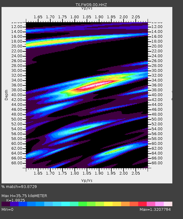
FW09 Farmers Branch - Earthquake Result Viewer
| Earthquake location: |
Northern Peru |
| Earthquake latitude/longitude: |
-4.5/-76.7 |
| Earthquake time(UTC): |
2021/11/28 (332) 10:52:14 GMT |
| Earthquake Depth: |
99 km |
| Earthquake Magnitude: |
7.4 Mi |
| Earthquake Catalog/Contributor: |
NEIC PDE/at |
|
| Network: |
TX Texas Seismological Network |
| Station: |
FW09 Farmers Branch |
| Lat/Lon: |
32.92 N/96.91 W |
| Elevation: |
311 m |
|
| Distance: |
41.9 deg |
| Az: |
334.187 deg |
| Baz: |
148.926 deg |
| Ray Param: |
0.07319741 |
| Estimated Moho Depth: |
35.75 km |
| Estimated Crust Vp/Vs: |
1.88 |
| Assumed Crust Vp: |
6.38 km/s |
| Estimated Crust Vs: |
3.389 km/s |
| Estimated Crust Poisson's Ratio: |
0.30 |
|
| Radial Match: |
93.8729 % |
| Radial Bump: |
400 |
| Transverse Match: |
83.39213 % |
| Transverse Bump: |
400 |
| SOD ConfigId: |
26694651 |
| Insert Time: |
2021-12-12 11:26:56.223 +0000 |
| GWidth: |
2.5 |
| Max Bumps: |
400 |
| Tol: |
0.001 |
|

Signal To Noise
| Channel | StoN | STA | LTA |
| TX:FW09:00:HHZ:20211128T10:59:23.950012Z | 15.782459 | 8.809997E-6 | 5.582145E-7 |
| TX:FW09:00:HH1:20211128T10:59:23.950012Z | 8.328026 | 3.2908763E-6 | 3.9515683E-7 |
| TX:FW09:00:HH2:20211128T10:59:23.950012Z | 2.1987944 | 1.3014765E-6 | 5.919046E-7 |
| Arrivals |
| Ps | 5.3 SECOND |
| PpPs | 15 SECOND |
| PsPs/PpSs | 20 SECOND |


