You are here: Home > Network List > TX - Texas Seismological Network Stations List
> Station FW12 Venus > Earthquake Result Viewer
FW12 Venus - Earthquake Result Viewer

| Earthquake location: |
Northern Peru |
| Earthquake latitude/longitude: |
-4.5/-76.7 |
| Earthquake time(UTC): |
2021/11/28 (332) 10:52:14 GMT |
| Earthquake Depth: |
99 km |
| Earthquake Magnitude: |
7.4 Mi |
| Earthquake Catalog/Contributor: |
NEIC PDE/at |
|
| Network: |
TX Texas Seismological Network |
| Station: |
FW12 Venus |
| Lat/Lon: |
32.50 N/97.15 W |
| Elevation: |
204 m |
|
| Distance: |
41.6 deg |
| Az: |
333.603 deg |
| Baz: |
148.364 deg |
| Ray Param: |
0.073343106 |
| Estimated Moho Depth: |
57.75 km |
| Estimated Crust Vp/Vs: |
1.79 |
| Assumed Crust Vp: |
6.38 km/s |
| Estimated Crust Vs: |
3.565 km/s |
| Estimated Crust Poisson's Ratio: |
0.27 |
|
| Radial Match: |
94.831055 % |
| Radial Bump: |
400 |
| Transverse Match: |
90.80075 % |
| Transverse Bump: |
400 |
| SOD ConfigId: |
26694651 |
| Insert Time: |
2021-12-12 11:26:59.571 +0000 |
| GWidth: |
2.5 |
| Max Bumps: |
400 |
| Tol: |
0.001 |
|
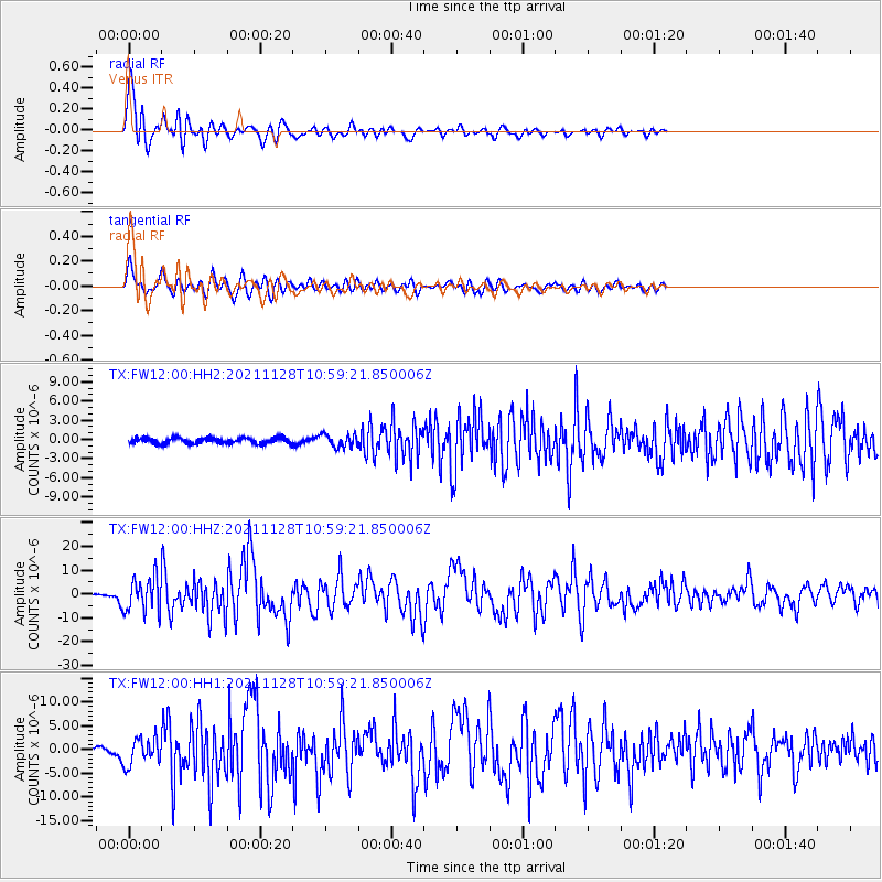
Signal To Noise
| Channel | StoN | STA | LTA |
| TX:FW12:00:HHZ:20211128T10:59:21.850006Z | 33.06892 | 7.1519257E-6 | 2.1627332E-7 |
| TX:FW12:00:HH1:20211128T10:59:21.850006Z | 8.154191 | 2.7744854E-6 | 3.4025268E-7 |
| TX:FW12:00:HH2:20211128T10:59:21.850006Z | 2.2367134 | 9.958904E-7 | 4.452472E-7 |
| Arrivals |
| Ps | 7.6 SECOND |
| PpPs | 24 SECOND |
| PsPs/PpSs | 31 SECOND |


