You are here: Home > Network List > TX - Texas Seismological Network Stations List
> Station MB01 Midkiff > Earthquake Result Viewer
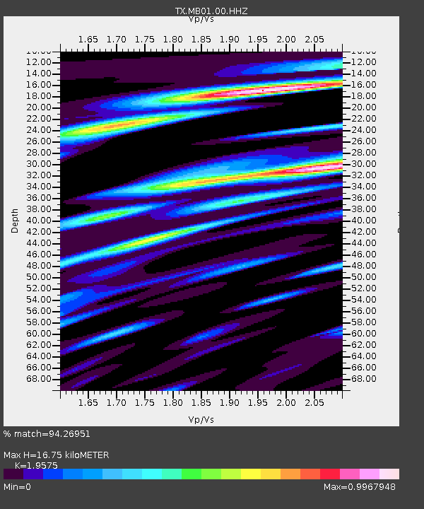
MB01 Midkiff - Earthquake Result Viewer
| Earthquake location: |
Northern Peru |
| Earthquake latitude/longitude: |
-4.5/-76.7 |
| Earthquake time(UTC): |
2021/11/28 (332) 10:52:14 GMT |
| Earthquake Depth: |
99 km |
| Earthquake Magnitude: |
7.4 Mi |
| Earthquake Catalog/Contributor: |
NEIC PDE/at |
|
| Network: |
TX Texas Seismological Network |
| Station: |
MB01 Midkiff |
| Lat/Lon: |
31.67 N/102.08 W |
| Elevation: |
859 m |
|
| Distance: |
43.3 deg |
| Az: |
327.821 deg |
| Baz: |
141.487 deg |
| Ray Param: |
0.07226877 |
| Estimated Moho Depth: |
16.75 km |
| Estimated Crust Vp/Vs: |
1.96 |
| Assumed Crust Vp: |
6.121 km/s |
| Estimated Crust Vs: |
3.127 km/s |
| Estimated Crust Poisson's Ratio: |
0.32 |
|
| Radial Match: |
94.26951 % |
| Radial Bump: |
400 |
| Transverse Match: |
78.46039 % |
| Transverse Bump: |
400 |
| SOD ConfigId: |
26694651 |
| Insert Time: |
2021-12-12 11:27:08.214 +0000 |
| GWidth: |
2.5 |
| Max Bumps: |
400 |
| Tol: |
0.001 |
|

Signal To Noise
| Channel | StoN | STA | LTA |
| TX:MB01:00:HHZ:20211128T10:59:35.839996Z | 13.280548 | 2.7549102E-6 | 2.0743948E-7 |
| TX:MB01:00:HH1:20211128T10:59:35.839996Z | 10.316867 | 1.0184208E-6 | 9.8714146E-8 |
| TX:MB01:00:HH2:20211128T10:59:35.839996Z | 4.2732744 | 7.903368E-7 | 1.8494876E-7 |
| Arrivals |
| Ps | 2.8 SECOND |
| PpPs | 7.7 SECOND |
| PsPs/PpSs | 10 SECOND |


