You are here: Home > Network List > TX - Texas Seismological Network Stations List
> Station PB32 CR 111 > Earthquake Result Viewer
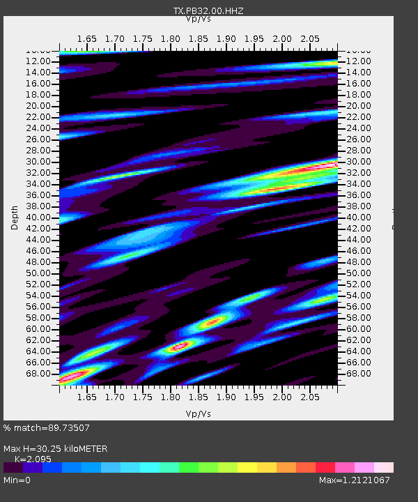
PB32 CR 111 - Earthquake Result Viewer
| Earthquake location: |
Northern Peru |
| Earthquake latitude/longitude: |
-4.5/-76.7 |
| Earthquake time(UTC): |
2021/11/28 (332) 10:52:14 GMT |
| Earthquake Depth: |
99 km |
| Earthquake Magnitude: |
7.4 Mi |
| Earthquake Catalog/Contributor: |
NEIC PDE/at |
|
| Network: |
TX Texas Seismological Network |
| Station: |
PB32 CR 111 |
| Lat/Lon: |
31.10 N/103.37 W |
| Elevation: |
861 m |
|
| Distance: |
43.6 deg |
| Az: |
326.063 deg |
| Baz: |
139.543 deg |
| Ray Param: |
0.072114326 |
| Estimated Moho Depth: |
30.25 km |
| Estimated Crust Vp/Vs: |
2.10 |
| Assumed Crust Vp: |
6.121 km/s |
| Estimated Crust Vs: |
2.921 km/s |
| Estimated Crust Poisson's Ratio: |
0.35 |
|
| Radial Match: |
89.73507 % |
| Radial Bump: |
400 |
| Transverse Match: |
78.260956 % |
| Transverse Bump: |
400 |
| SOD ConfigId: |
26694651 |
| Insert Time: |
2021-12-12 11:27:51.460 +0000 |
| GWidth: |
2.5 |
| Max Bumps: |
400 |
| Tol: |
0.001 |
|

Signal To Noise
| Channel | StoN | STA | LTA |
| TX:PB32:00:HHZ:20211128T10:59:37.980011Z | 53.321976 | 1.5223931E-6 | 2.8550952E-8 |
| TX:PB32:00:HH1:20211128T10:59:37.980011Z | 14.297124 | 7.73024E-7 | 5.4068494E-8 |
| TX:PB32:00:HH2:20211128T10:59:37.980011Z | 15.582098 | 1.118873E-6 | 7.180503E-8 |
| Arrivals |
| Ps | 5.7 SECOND |
| PpPs | 15 SECOND |
| PsPs/PpSs | 20 SECOND |


