You are here: Home > Network List > TX - Texas Seismological Network Stations List
> Station PH03 Pantex > Earthquake Result Viewer
PH03 Pantex - Earthquake Result Viewer
| Earthquake location: |
Northern Peru |
| Earthquake latitude/longitude: |
-4.5/-76.7 |
| Earthquake time(UTC): |
2021/11/28 (332) 10:52:14 GMT |
| Earthquake Depth: |
99 km |
| Earthquake Magnitude: |
7.4 Mi |
| Earthquake Catalog/Contributor: |
NEIC PDE/at |
|
| Network: |
TX Texas Seismological Network |
| Station: |
PH03 Pantex |
| Lat/Lon: |
35.36 N/101.55 W |
| Elevation: |
1061 m |
|
| Distance: |
46.0 deg |
| Az: |
331.479 deg |
| Baz: |
144.383 deg |
| Ray Param: |
0.07059613 |
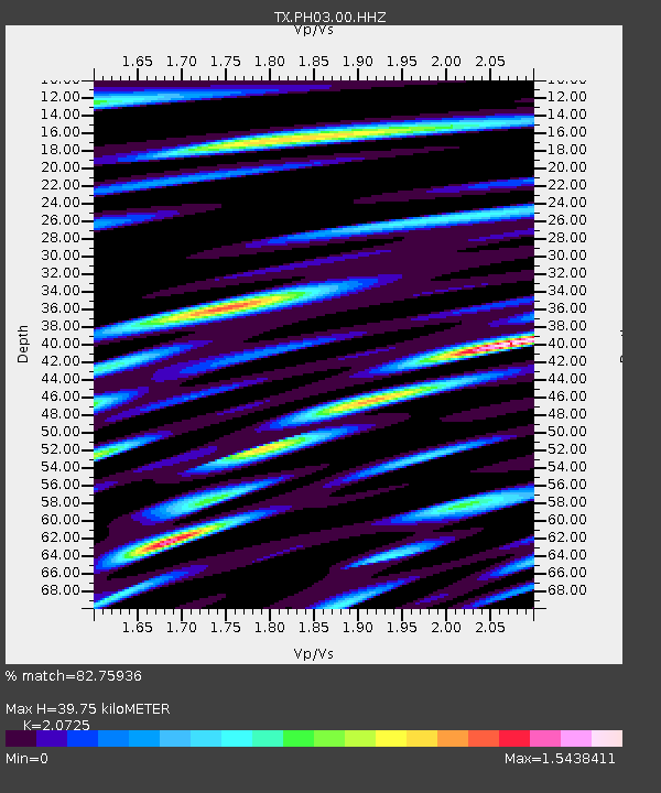
| Estimated Moho Depth: |
39.75 km |
| Estimated Crust Vp/Vs: |
2.07 |
| Assumed Crust Vp: |
6.426 km/s |
| Estimated Crust Vs: |
3.101 km/s |
| Estimated Crust Poisson's Ratio: |
0.35 |
|
| Radial Match: |
82.75936 % |
| Radial Bump: |
400 |
| Transverse Match: |
77.7537 % |
| Transverse Bump: |
400 |
| SOD ConfigId: |
26694651 |
| Insert Time: |
2021-12-12 11:27:56.045 +0000 |
| GWidth: |
2.5 |
| Max Bumps: |
400 |
| Tol: |
0.001 |
|

Signal To Noise
| Channel | StoN | STA | LTA |
| TX:PH03:00:HHZ:20211128T10:59:57.01001Z | 30.60311 | 6.2194085E-6 | 2.0322798E-7 |
| TX:PH03:00:HH1:20211128T10:59:57.01001Z | 3.6154292 | 1.7621813E-6 | 4.874059E-7 |
| TX:PH03:00:HH2:20211128T10:59:57.01001Z | 3.3254445 | 1.4129338E-6 | 4.248857E-7 |
| Arrivals |
| Ps | 7.0 SECOND |
| PpPs | 18 SECOND |
| PsPs/PpSs | 25 SECOND |


