You are here: Home > Network List > TX - Texas Seismological Network Stations List
> Station MB10 Stanton > Earthquake Result Viewer
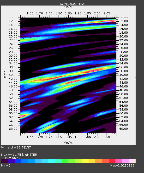
MB10 Stanton - Earthquake Result Viewer
| Earthquake location: |
Northern Peru |
| Earthquake latitude/longitude: |
-4.5/-76.7 |
| Earthquake time(UTC): |
2021/11/28 (332) 10:52:14 GMT |
| Earthquake Depth: |
99 km |
| Earthquake Magnitude: |
7.4 Mi |
| Earthquake Catalog/Contributor: |
NEIC PDE/at |
|
| Network: |
TX Texas Seismological Network |
| Station: |
MB10 Stanton |
| Lat/Lon: |
32.27 N/101.79 W |
| Elevation: |
813 m |
|
| Distance: |
43.7 deg |
| Az: |
328.638 deg |
| Baz: |
142.233 deg |
| Ray Param: |
0.07208581 |
| Estimated Moho Depth: |
11.75 km |
| Estimated Crust Vp/Vs: |
2.10 |
| Assumed Crust Vp: |
6.426 km/s |
| Estimated Crust Vs: |
3.064 km/s |
| Estimated Crust Poisson's Ratio: |
0.35 |
|
| Radial Match: |
92.48157 % |
| Radial Bump: |
400 |
| Transverse Match: |
79.6673 % |
| Transverse Bump: |
400 |
| SOD ConfigId: |
26694651 |
| Insert Time: |
2021-12-12 11:28:23.705 +0000 |
| GWidth: |
2.5 |
| Max Bumps: |
400 |
| Tol: |
0.001 |
|

Signal To Noise
| Channel | StoN | STA | LTA |
| TX:MB10:01:HHZ:20211128T10:59:38.369995Z | 14.790311 | 5.450547E-6 | 3.6852148E-7 |
| TX:MB10:01:HHN:20211128T10:59:38.369995Z | 4.8733587 | 2.2180118E-6 | 4.5513E-7 |
| TX:MB10:01:HHE:20211128T10:59:38.369995Z | 5.1515923 | 1.826365E-6 | 3.5452436E-7 |
| Arrivals |
| Ps | 2.1 SECOND |
| PpPs | 5.4 SECOND |
| PsPs/PpSs | 7.5 SECOND |


