You are here: Home > Network List > UO - University of Oregon Regional Network Stations List
> Station PINE Pine Mountain Observatory, OR > Earthquake Result Viewer
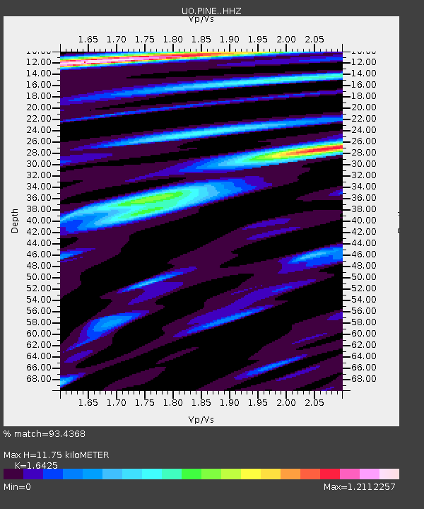
PINE Pine Mountain Observatory, OR - Earthquake Result Viewer
| Earthquake location: |
Northern Peru |
| Earthquake latitude/longitude: |
-4.5/-76.7 |
| Earthquake time(UTC): |
2021/11/28 (332) 10:52:14 GMT |
| Earthquake Depth: |
99 km |
| Earthquake Magnitude: |
7.4 Mi |
| Earthquake Catalog/Contributor: |
NEIC PDE/at |
|
| Network: |
UO University of Oregon Regional Network |
| Station: |
PINE Pine Mountain Observatory, OR |
| Lat/Lon: |
43.79 N/120.94 W |
| Elevation: |
1916 m |
|
| Distance: |
62.4 deg |
| Az: |
325.237 deg |
| Baz: |
128.284 deg |
| Ray Param: |
0.05998447 |
| Estimated Moho Depth: |
11.75 km |
| Estimated Crust Vp/Vs: |
1.64 |
| Assumed Crust Vp: |
6.597 km/s |
| Estimated Crust Vs: |
4.017 km/s |
| Estimated Crust Poisson's Ratio: |
0.21 |
|
| Radial Match: |
93.4368 % |
| Radial Bump: |
400 |
| Transverse Match: |
88.34976 % |
| Transverse Bump: |
400 |
| SOD ConfigId: |
26694651 |
| Insert Time: |
2021-12-12 11:29:14.307 +0000 |
| GWidth: |
2.5 |
| Max Bumps: |
400 |
| Tol: |
0.001 |
|

Signal To Noise
| Channel | StoN | STA | LTA |
| UO:PINE: :HHZ:20211128T11:01:55.590027Z | 11.952835 | 5.38585E-6 | 4.505918E-7 |
| UO:PINE: :HHN:20211128T11:01:55.590027Z | 3.7340214 | 1.9142446E-6 | 5.1264965E-7 |
| UO:PINE: :HHE:20211128T11:01:55.590027Z | 5.475243 | 1.9396118E-6 | 3.5425128E-7 |
| Arrivals |
| Ps | 1.2 SECOND |
| PpPs | 4.5 SECOND |
| PsPs/PpSs | 5.7 SECOND |


