You are here: Home > Network List > YL01 - Himalayan Nepal Tibet Experiment Stations List
> Station SIND YL.SIND > Earthquake Result Viewer
SIND YL.SIND - Earthquake Result Viewer
| Earthquake location: |
Southeast Of Honshu, Japan |
| Earthquake latitude/longitude: |
29.3/139.0 |
| Earthquake time(UTC): |
2002/08/02 (214) 23:11:39 GMT |
| Earthquake Depth: |
426 km |
| Earthquake Magnitude: |
5.5 MB, 6.3 MW, 6.3 MW |
| Earthquake Catalog/Contributor: |
WHDF/NEIC |
|
| Network: |
YL Himalayan Nepal Tibet Experiment |
| Station: |
SIND YL.SIND |
| Lat/Lon: |
27.21 N/85.91 E |
| Elevation: |
465 m |
|
| Distance: |
46.5 deg |
| Az: |
280.89 deg |
| Baz: |
74.432 deg |
| Ray Param: |
0.06875818 |
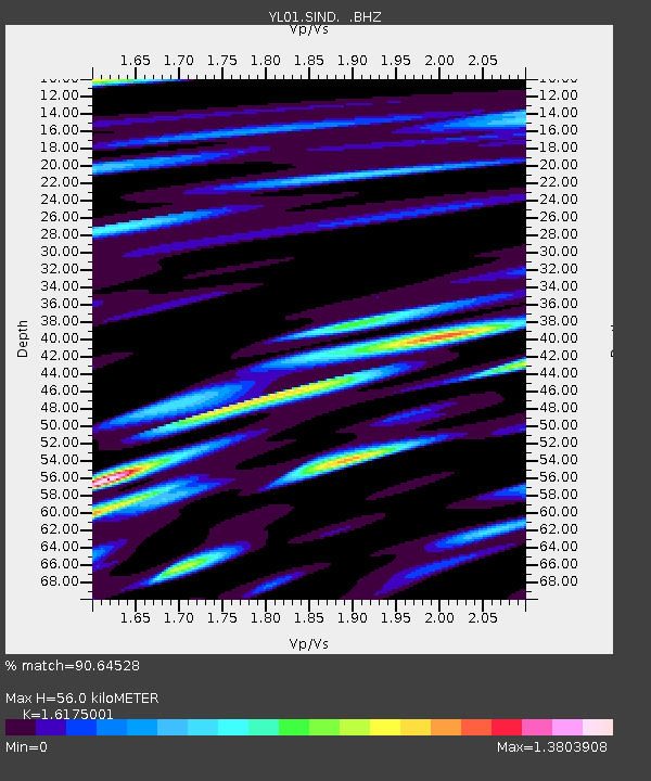
| Estimated Moho Depth: |
56.0 km |
| Estimated Crust Vp/Vs: |
1.62 |
| Assumed Crust Vp: |
6.142 km/s |
| Estimated Crust Vs: |
3.797 km/s |
| Estimated Crust Poisson's Ratio: |
0.19 |
|
| Radial Match: |
90.64528 % |
| Radial Bump: |
400 |
| Transverse Match: |
91.32476 % |
| Transverse Bump: |
400 |
| SOD ConfigId: |
16844 |
| Insert Time: |
2010-02-26 16:11:56.231 +0000 |
| GWidth: |
2.5 |
| Max Bumps: |
400 |
| Tol: |
0.001 |
|
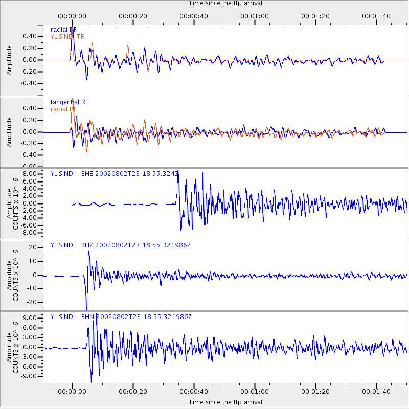
Signal To Noise
| Channel | StoN | STA | LTA |
| YL:SIND: :BHZ:20020802T23:18:55.321986Z | 39.96893 | 6.0725965E-6 | 1.5193294E-7 |
| YL:SIND: :BHN:20020802T23:18:55.321986Z | 1.7546787 | 2.5952966E-7 | 1.4790723E-7 |
| YL:SIND: :BHE:20020802T23:18:55.324Z | 10.597508 | 1.96554E-6 | 1.8547188E-7 |
| Arrivals |
| Ps | 6.0 SECOND |
| PpPs | 23 SECOND |
| PsPs/PpSs | 28 SECOND |


