You are here: Home > Network List > US - United States National Seismic Network Stations List
> Station AAM Ann Arbor, Michigan, USA > Earthquake Result Viewer
AAM Ann Arbor, Michigan, USA - Earthquake Result Viewer
| Earthquake location: |
Northern Peru |
| Earthquake latitude/longitude: |
-4.5/-76.7 |
| Earthquake time(UTC): |
2021/11/28 (332) 10:52:14 GMT |
| Earthquake Depth: |
99 km |
| Earthquake Magnitude: |
7.4 Mi |
| Earthquake Catalog/Contributor: |
NEIC PDE/at |
|
| Network: |
US United States National Seismic Network |
| Station: |
AAM Ann Arbor, Michigan, USA |
| Lat/Lon: |
42.30 N/83.66 W |
| Elevation: |
172 m |
|
| Distance: |
47.0 deg |
| Az: |
352.944 deg |
| Baz: |
170.498 deg |
| Ray Param: |
0.06993588 |
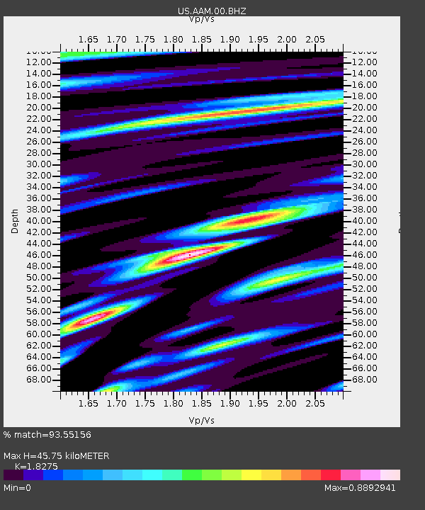
| Estimated Moho Depth: |
45.75 km |
| Estimated Crust Vp/Vs: |
1.83 |
| Assumed Crust Vp: |
6.483 km/s |
| Estimated Crust Vs: |
3.547 km/s |
| Estimated Crust Poisson's Ratio: |
0.29 |
|
| Radial Match: |
93.55156 % |
| Radial Bump: |
400 |
| Transverse Match: |
69.688675 % |
| Transverse Bump: |
400 |
| SOD ConfigId: |
26694651 |
| Insert Time: |
2021-12-12 11:29:37.957 +0000 |
| GWidth: |
2.5 |
| Max Bumps: |
400 |
| Tol: |
0.001 |
|

Signal To Noise
| Channel | StoN | STA | LTA |
| US:AAM:00:BHZ:20211128T11:00:04.799988Z | 7.09524 | 4.722743E-6 | 6.656213E-7 |
| US:AAM:00:BH1:20211128T11:00:04.799988Z | 6.609892 | 2.2547E-6 | 3.4110994E-7 |
| US:AAM:00:BH2:20211128T11:00:04.799988Z | 2.3618665 | 1.38491E-6 | 5.863625E-7 |
| Arrivals |
| Ps | 6.2 SECOND |
| PpPs | 19 SECOND |
| PsPs/PpSs | 25 SECOND |


