You are here: Home > Network List > US - United States National Seismic Network Stations List
> Station AMTX Amarillo, Texas, USA > Earthquake Result Viewer
AMTX Amarillo, Texas, USA - Earthquake Result Viewer
*The percent match for this event was below the threshold and hence no stack was calculated.
| Earthquake location: |
Northern Peru |
| Earthquake latitude/longitude: |
-4.5/-76.7 |
| Earthquake time(UTC): |
2021/11/28 (332) 10:52:14 GMT |
| Earthquake Depth: |
99 km |
| Earthquake Magnitude: |
7.4 Mi |
| Earthquake Catalog/Contributor: |
NEIC PDE/at |
|
| Network: |
US United States National Seismic Network |
| Station: |
AMTX Amarillo, Texas, USA |
| Lat/Lon: |
34.53 N/101.41 W |
| Elevation: |
1010 m |
|
| Distance: |
45.3 deg |
| Az: |
330.938 deg |
| Baz: |
144.085 deg |
| Ray Param: |
$rayparam |
*The percent match for this event was below the threshold and hence was not used in the summary stack. |
|
| Radial Match: |
91.602745 % |
| Radial Bump: |
400 |
| Transverse Match: |
80.99211 % |
| Transverse Bump: |
400 |
| SOD ConfigId: |
26694651 |
| Insert Time: |
2021-12-12 11:29:44.225 +0000 |
| GWidth: |
2.5 |
| Max Bumps: |
400 |
| Tol: |
0.001 |
|
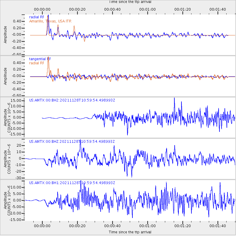
Signal To Noise
| Channel | StoN | STA | LTA |
| US:AMTX:00:BHZ:20211128T10:59:54.498993Z | 9.214839 | 4.3112395E-6 | 4.6785837E-7 |
| US:AMTX:00:BH1:20211128T10:59:54.498993Z | 7.0001173 | 1.9828713E-6 | 2.8326255E-7 |
| US:AMTX:00:BH2:20211128T10:59:54.498993Z | 4.754862 | 1.5097556E-6 | 3.175183E-7 |
| Arrivals |
| Ps | |
| PpPs | |
| PsPs/PpSs | |


