You are here: Home > Network List > US - United States National Seismic Network Stations List
> Station BMO Blue Mountains Array (Baker), Oregon, USA > Earthquake Result Viewer
BMO Blue Mountains Array (Baker), Oregon, USA - Earthquake Result Viewer
| Earthquake location: |
Northern Peru |
| Earthquake latitude/longitude: |
-4.5/-76.7 |
| Earthquake time(UTC): |
2021/11/28 (332) 10:52:14 GMT |
| Earthquake Depth: |
99 km |
| Earthquake Magnitude: |
7.4 Mi |
| Earthquake Catalog/Contributor: |
NEIC PDE/at |
|
| Network: |
US United States National Seismic Network |
| Station: |
BMO Blue Mountains Array (Baker), Oregon, USA |
| Lat/Lon: |
44.85 N/117.31 W |
| Elevation: |
1189 m |
|
| Distance: |
61.1 deg |
| Az: |
328.066 deg |
| Baz: |
132.155 deg |
| Ray Param: |
0.060831644 |
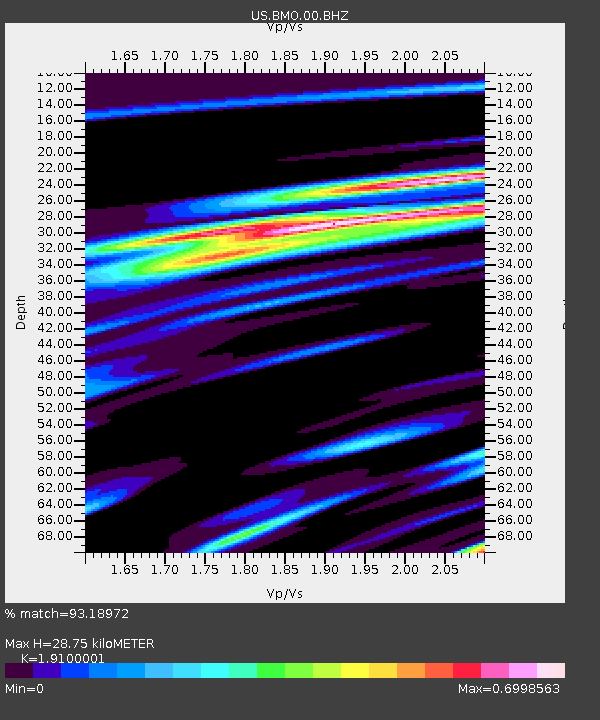
| Estimated Moho Depth: |
28.75 km |
| Estimated Crust Vp/Vs: |
1.91 |
| Assumed Crust Vp: |
6.571 km/s |
| Estimated Crust Vs: |
3.44 km/s |
| Estimated Crust Poisson's Ratio: |
0.31 |
|
| Radial Match: |
93.18972 % |
| Radial Bump: |
400 |
| Transverse Match: |
76.538704 % |
| Transverse Bump: |
400 |
| SOD ConfigId: |
26694651 |
| Insert Time: |
2021-12-12 11:29:50.035 +0000 |
| GWidth: |
2.5 |
| Max Bumps: |
400 |
| Tol: |
0.001 |
|

Signal To Noise
| Channel | StoN | STA | LTA |
| US:BMO:00:BHZ:20211128T11:01:46.848999Z | 9.027933 | 3.1955526E-6 | 3.539628E-7 |
| US:BMO:00:BH1:20211128T11:01:46.848999Z | 5.9500394 | 6.3017006E-7 | 1.0591023E-7 |
| US:BMO:00:BH2:20211128T11:01:46.848999Z | 5.340224 | 1.6525906E-6 | 3.0946094E-7 |
| Arrivals |
| Ps | 4.2 SECOND |
| PpPs | 12 SECOND |
| PsPs/PpSs | 16 SECOND |


