You are here: Home > Network List > US - United States National Seismic Network Stations List
> Station DGMT Dagmar, Montana, USA > Earthquake Result Viewer
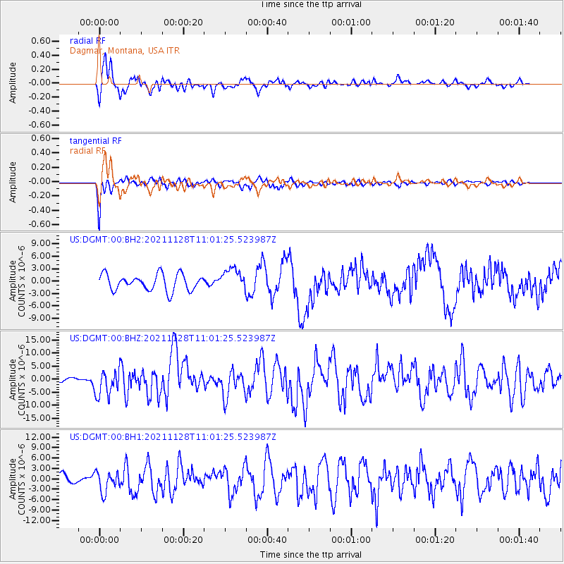
DGMT Dagmar, Montana, USA - Earthquake Result Viewer
*The percent match for this event was below the threshold and hence no stack was calculated.
| Earthquake location: |
Northern Peru |
| Earthquake latitude/longitude: |
-4.5/-76.7 |
| Earthquake time(UTC): |
2021/11/28 (332) 10:52:14 GMT |
| Earthquake Depth: |
99 km |
| Earthquake Magnitude: |
7.4 Mi |
| Earthquake Catalog/Contributor: |
NEIC PDE/at |
|
| Network: |
US United States National Seismic Network |
| Station: |
DGMT Dagmar, Montana, USA |
| Lat/Lon: |
48.47 N/104.20 W |
| Elevation: |
0.0 m |
|
| Distance: |
58.0 deg |
| Az: |
338.751 deg |
| Baz: |
147.117 deg |
| Ray Param: |
$rayparam |
*The percent match for this event was below the threshold and hence was not used in the summary stack. |
|
| Radial Match: |
77.316536 % |
| Radial Bump: |
400 |
| Transverse Match: |
84.49043 % |
| Transverse Bump: |
371 |
| SOD ConfigId: |
26694651 |
| Insert Time: |
2021-12-12 11:29:59.151 +0000 |
| GWidth: |
2.5 |
| Max Bumps: |
400 |
| Tol: |
0.001 |
|
Signal To Noise
| Channel | StoN | STA | LTA |
| US:DGMT:00:BHZ:20211128T11:01:25.523987Z | 6.902113 | 4.9834475E-6 | 7.2201766E-7 |
| US:DGMT:00:BH1:20211128T11:01:25.523987Z | 1.9991907 | 2.927874E-6 | 1.4645296E-6 |
| US:DGMT:00:BH2:20211128T11:01:25.523987Z | 1.3564532 | 2.6597943E-6 | 1.960845E-6 |
| Arrivals |
| Ps | |
| PpPs | |
| PsPs/PpSs | |


