You are here: Home > Network List > US - United States National Seismic Network Stations List
> Station GLMI Grayling, Michigan, USA > Earthquake Result Viewer
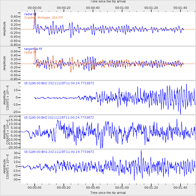
GLMI Grayling, Michigan, USA - Earthquake Result Viewer
*The percent match for this event was below the threshold and hence no stack was calculated.
| Earthquake location: |
Northern Peru |
| Earthquake latitude/longitude: |
-4.5/-76.7 |
| Earthquake time(UTC): |
2021/11/28 (332) 10:52:14 GMT |
| Earthquake Depth: |
99 km |
| Earthquake Magnitude: |
7.4 Mi |
| Earthquake Catalog/Contributor: |
NEIC PDE/at |
|
| Network: |
US United States National Seismic Network |
| Station: |
GLMI Grayling, Michigan, USA |
| Lat/Lon: |
44.82 N/84.62 W |
| Elevation: |
387 m |
|
| Distance: |
49.6 deg |
| Az: |
352.606 deg |
| Baz: |
169.613 deg |
| Ray Param: |
$rayparam |
*The percent match for this event was below the threshold and hence was not used in the summary stack. |
|
| Radial Match: |
78.14493 % |
| Radial Bump: |
400 |
| Transverse Match: |
70.000755 % |
| Transverse Bump: |
400 |
| SOD ConfigId: |
26694651 |
| Insert Time: |
2021-12-12 11:30:09.094 +0000 |
| GWidth: |
2.5 |
| Max Bumps: |
400 |
| Tol: |
0.001 |
|
Signal To Noise
| Channel | StoN | STA | LTA |
| US:GLMI:00:BHZ:20211128T11:00:24.773987Z | 5.3487825 | 3.9056754E-6 | 7.3019896E-7 |
| US:GLMI:00:BH1:20211128T11:00:24.773987Z | 2.988714 | 3.2973114E-6 | 1.1032542E-6 |
| US:GLMI:00:BH2:20211128T11:00:24.773987Z | 2.8543818 | 1.4576151E-6 | 5.1065877E-7 |
| Arrivals |
| Ps | |
| PpPs | |
| PsPs/PpSs | |


