You are here: Home > Network List > US - United States National Seismic Network Stations List
> Station NATX Nacogdoches, Texas, USA > Earthquake Result Viewer
NATX Nacogdoches, Texas, USA - Earthquake Result Viewer
| Earthquake location: |
Northern Peru |
| Earthquake latitude/longitude: |
-4.5/-76.7 |
| Earthquake time(UTC): |
2021/11/28 (332) 10:52:14 GMT |
| Earthquake Depth: |
99 km |
| Earthquake Magnitude: |
7.4 Mi |
| Earthquake Catalog/Contributor: |
NEIC PDE/at |
|
| Network: |
US United States National Seismic Network |
| Station: |
NATX Nacogdoches, Texas, USA |
| Lat/Lon: |
31.76 N/94.66 W |
| Elevation: |
168 m |
|
| Distance: |
39.9 deg |
| Az: |
335.832 deg |
| Baz: |
151.369 deg |
| Ray Param: |
0.074383624 |
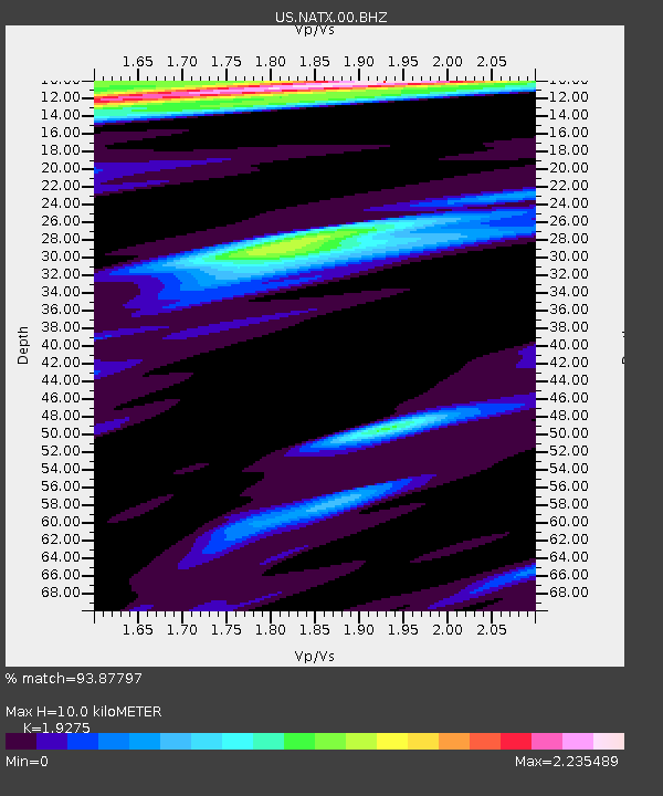
| Estimated Moho Depth: |
10.0 km |
| Estimated Crust Vp/Vs: |
1.93 |
| Assumed Crust Vp: |
5.738 km/s |
| Estimated Crust Vs: |
2.977 km/s |
| Estimated Crust Poisson's Ratio: |
0.32 |
|
| Radial Match: |
93.87797 % |
| Radial Bump: |
362 |
| Transverse Match: |
71.31021 % |
| Transverse Bump: |
400 |
| SOD ConfigId: |
26694651 |
| Insert Time: |
2021-12-12 11:30:37.126 +0000 |
| GWidth: |
2.5 |
| Max Bumps: |
400 |
| Tol: |
0.001 |
|

Signal To Noise
| Channel | StoN | STA | LTA |
| US:NATX:00:BHZ:20211128T10:59:07.950012Z | 13.139028 | 6.0705984E-6 | 4.6202797E-7 |
| US:NATX:00:BH1:20211128T10:59:07.950012Z | 3.4934356 | 3.4356426E-6 | 9.834566E-7 |
| US:NATX:00:BH2:20211128T10:59:07.950012Z | 1.588463 | 2.4023684E-6 | 1.5123856E-6 |
| Arrivals |
| Ps | 1.7 SECOND |
| PpPs | 4.9 SECOND |
| PsPs/PpSs | 6.6 SECOND |


