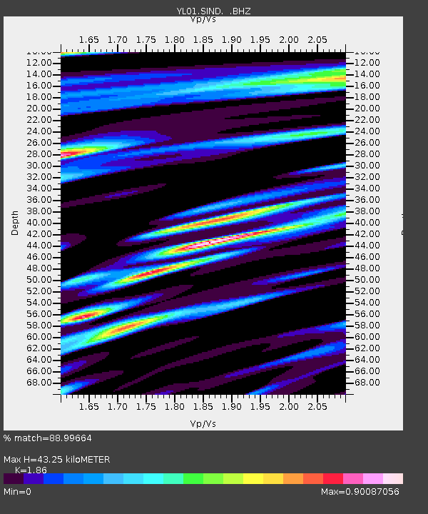
SIND YL.SIND - Earthquake Result Viewer

Earthquake location: Mariana Islands
Earthquake latitude/longitude: 14.1/146.2
Earthquake time(UTC): 2002/08/14 (226) 13:57:52 GMT
Earthquake Depth: 30 km
Earthquake Magnitude: 6.1 MB, 6.4 MS, 6.5 MW, 6.4 MW
Earthquake Catalog/Contributor: WHDF/NEIC
Network: YL Himalayan Nepal Tibet Experiment
Station: SIND YL.SIND
Lat/Lon: 27.21 N/85.91 E
Elevation: 465 m
Distance: 57.4 deg
Az: 293.383 deg
Baz: 90.211 deg
Ray Param: 0.06344817
Estimated Moho Depth: 43.25 km
Estimated Crust Vp/Vs: 1.86
Assumed Crust Vp: 6.142 km/s
Estimated Crust Vs: 3.302 km/s
Estimated Crust Poisson's Ratio: 0.30
Radial Match: 88.99664 %
Radial Bump: 400
Transverse Match: 83.354294 %
Transverse Bump: 400
SOD ConfigId: 16844
Insert Time: 2010-02-26 16:11:58.035 +0000
GWidth: 2.5
Max Bumps: 400
Tol: 0.001

Signal To Noise

ChannelStoNSTALTA
YL:SIND: :BHZ:20020814T14:07:07.156021Z3.6046157.931682E-72.2004242E-7
YL:SIND: :BHN:20020814T14:07:07.154006Z1.25810723.6815197E-72.926237E-7
YL:SIND: :BHE:20020814T14:07:07.156021Z1.20351343.0849063E-72.5632505E-7
Arrivals
Ps6.3 SECOND
PpPs19 SECOND
PsPs/PpSs26 SECOND