You are here: Home > Network List > UU - University of Utah Regional Network Stations List
> Station FOR6 FORGE > Earthquake Result Viewer
FOR6 FORGE - Earthquake Result Viewer
| Earthquake location: |
Northern Peru |
| Earthquake latitude/longitude: |
-4.5/-76.7 |
| Earthquake time(UTC): |
2021/11/28 (332) 10:52:14 GMT |
| Earthquake Depth: |
99 km |
| Earthquake Magnitude: |
7.4 Mi |
| Earthquake Catalog/Contributor: |
NEIC PDE/at |
|
| Network: |
UU University of Utah Regional Network |
| Station: |
FOR6 FORGE |
| Lat/Lon: |
38.49 N/112.79 W |
| Elevation: |
2421 m |
|
| Distance: |
54.3 deg |
| Az: |
325.292 deg |
| Baz: |
133.667 deg |
| Ray Param: |
0.065262206 |
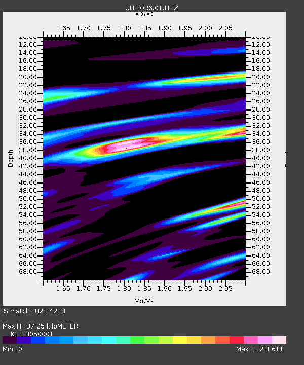
| Estimated Moho Depth: |
37.25 km |
| Estimated Crust Vp/Vs: |
1.81 |
| Assumed Crust Vp: |
6.276 km/s |
| Estimated Crust Vs: |
3.477 km/s |
| Estimated Crust Poisson's Ratio: |
0.28 |
|
| Radial Match: |
82.14218 % |
| Radial Bump: |
400 |
| Transverse Match: |
79.07571 % |
| Transverse Bump: |
400 |
| SOD ConfigId: |
26694651 |
| Insert Time: |
2021-12-12 11:31:12.265 +0000 |
| GWidth: |
2.5 |
| Max Bumps: |
400 |
| Tol: |
0.001 |
|

Signal To Noise
| Channel | StoN | STA | LTA |
| UU:FOR6:01:HHZ:20211128T11:00:59.26001Z | 15.09559 | 3.8509756E-6 | 2.5510602E-7 |
| UU:FOR6:01:HHN:20211128T11:00:59.26001Z | 7.2028246 | 1.5111589E-6 | 2.0980087E-7 |
| UU:FOR6:01:HHE:20211128T11:00:59.26001Z | 6.422617 | 1.8005155E-6 | 2.8033986E-7 |
| Arrivals |
| Ps | 5.0 SECOND |
| PpPs | 16 SECOND |
| PsPs/PpSs | 21 SECOND |


