You are here: Home > Network List > UW - Pacific Northwest Regional Seismic Network Stations List
> Station LCCR Clarks, OR, USA > Earthquake Result Viewer
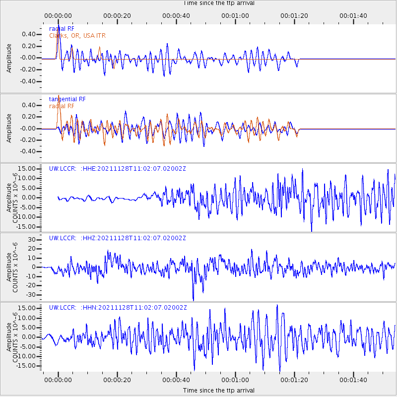
LCCR Clarks, OR, USA - Earthquake Result Viewer
*The percent match for this event was below the threshold and hence no stack was calculated.
| Earthquake location: |
Northern Peru |
| Earthquake latitude/longitude: |
-4.5/-76.7 |
| Earthquake time(UTC): |
2021/11/28 (332) 10:52:14 GMT |
| Earthquake Depth: |
99 km |
| Earthquake Magnitude: |
7.4 Mi |
| Earthquake Catalog/Contributor: |
NEIC PDE/at |
|
| Network: |
UW Pacific Northwest Regional Seismic Network |
| Station: |
LCCR Clarks, OR, USA |
| Lat/Lon: |
45.21 N/122.48 W |
| Elevation: |
271 m |
|
| Distance: |
64.1 deg |
| Az: |
325.731 deg |
| Baz: |
127.431 deg |
| Ray Param: |
$rayparam |
*The percent match for this event was below the threshold and hence was not used in the summary stack. |
|
| Radial Match: |
78.194916 % |
| Radial Bump: |
400 |
| Transverse Match: |
79.493614 % |
| Transverse Bump: |
400 |
| SOD ConfigId: |
26694651 |
| Insert Time: |
2021-12-12 11:32:15.717 +0000 |
| GWidth: |
2.5 |
| Max Bumps: |
400 |
| Tol: |
0.001 |
|
Signal To Noise
| Channel | StoN | STA | LTA |
| UW:LCCR: :HHZ:20211128T11:02:07.02002Z | 11.541083 | 5.5050864E-6 | 4.769991E-7 |
| UW:LCCR: :HHN:20211128T11:02:07.02002Z | 2.277693 | 1.8014314E-6 | 7.909017E-7 |
| UW:LCCR: :HHE:20211128T11:02:07.02002Z | 2.5437026 | 1.7679605E-6 | 6.950343E-7 |
| Arrivals |
| Ps | |
| PpPs | |
| PsPs/PpSs | |


