You are here: Home > Network List > UW - Pacific Northwest Regional Seismic Network Stations List
> Station LEID Weyerhaeuser Tree Farm, Grays Harbor County, WA, USA > Earthquake Result Viewer
LEID Weyerhaeuser Tree Farm, Grays Harbor County, WA, USA - Earthquake Result Viewer
| Earthquake location: |
Northern Peru |
| Earthquake latitude/longitude: |
-4.5/-76.7 |
| Earthquake time(UTC): |
2021/11/28 (332) 10:52:14 GMT |
| Earthquake Depth: |
99 km |
| Earthquake Magnitude: |
7.4 Mi |
| Earthquake Catalog/Contributor: |
NEIC PDE/at |
|
| Network: |
UW Pacific Northwest Regional Seismic Network |
| Station: |
LEID Weyerhaeuser Tree Farm, Grays Harbor County, WA, USA |
| Lat/Lon: |
46.83 N/123.47 W |
| Elevation: |
535 m |
|
| Distance: |
65.7 deg |
| Az: |
326.698 deg |
| Baz: |
127.134 deg |
| Ray Param: |
0.05787231 |
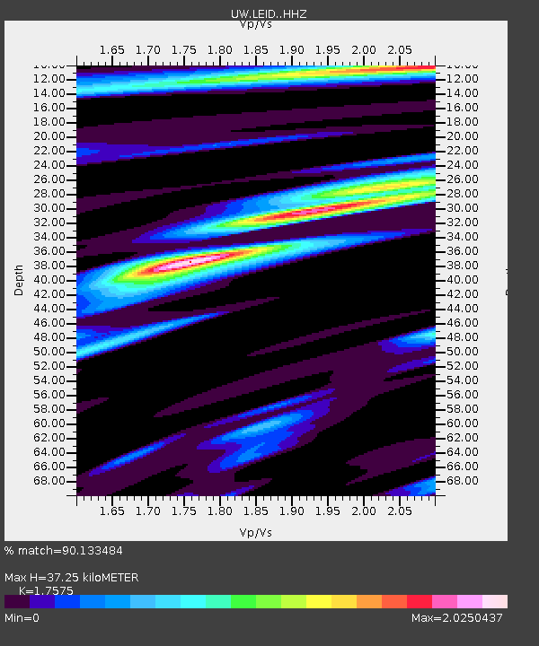
| Estimated Moho Depth: |
37.25 km |
| Estimated Crust Vp/Vs: |
1.76 |
| Assumed Crust Vp: |
6.566 km/s |
| Estimated Crust Vs: |
3.736 km/s |
| Estimated Crust Poisson's Ratio: |
0.26 |
|
| Radial Match: |
90.133484 % |
| Radial Bump: |
400 |
| Transverse Match: |
86.80847 % |
| Transverse Bump: |
400 |
| SOD ConfigId: |
26694651 |
| Insert Time: |
2021-12-12 11:32:18.689 +0000 |
| GWidth: |
2.5 |
| Max Bumps: |
400 |
| Tol: |
0.001 |
|

Signal To Noise
| Channel | StoN | STA | LTA |
| UW:LEID: :HHZ:20211128T11:02:16.919983Z | 8.707127 | 4.8495713E-6 | 5.569657E-7 |
| UW:LEID: :HHN:20211128T11:02:16.919983Z | 2.329396 | 2.1015233E-6 | 9.0217515E-7 |
| UW:LEID: :HHE:20211128T11:02:16.919983Z | 3.2480016 | 2.4779058E-6 | 7.6290166E-7 |
| Arrivals |
| Ps | 4.5 SECOND |
| PpPs | 15 SECOND |
| PsPs/PpSs | 19 SECOND |


