You are here: Home > Network List > UW - Pacific Northwest Regional Seismic Network Stations List
> Station UMAT Pilot Rock, OR, USA > Earthquake Result Viewer
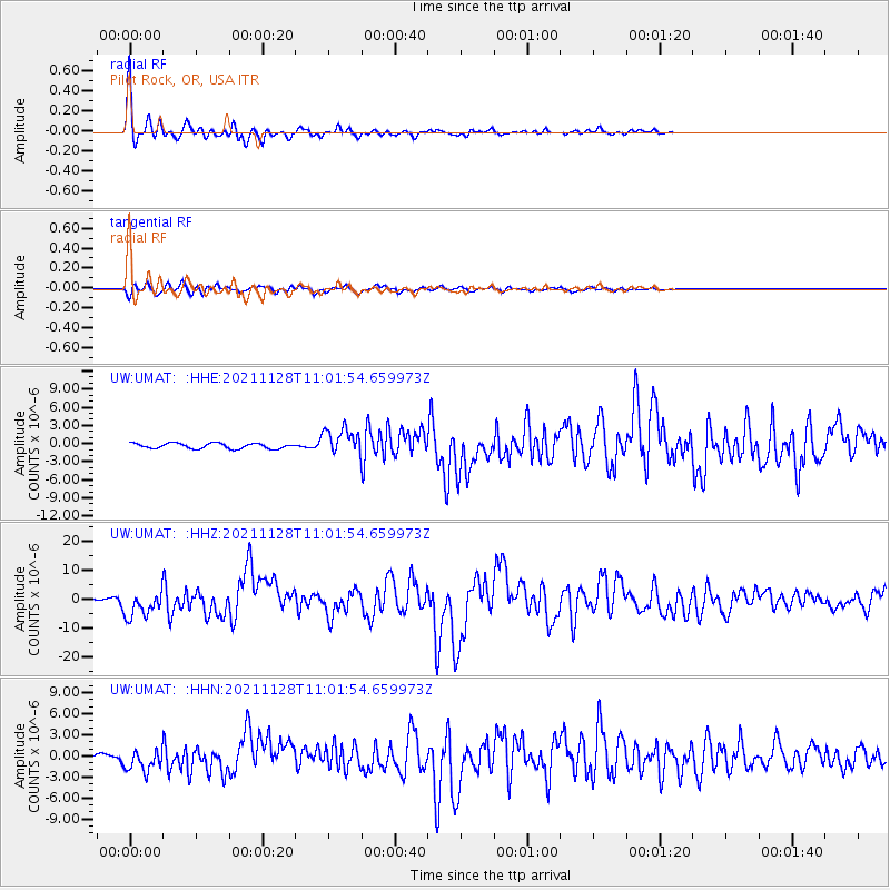
UMAT Pilot Rock, OR, USA - Earthquake Result Viewer
| Earthquake location: |
Northern Peru |
| Earthquake latitude/longitude: |
-4.5/-76.7 |
| Earthquake time(UTC): |
2021/11/28 (332) 10:52:14 GMT |
| Earthquake Depth: |
99 km |
| Earthquake Magnitude: |
7.4 Mi |
| Earthquake Catalog/Contributor: |
NEIC PDE/at |
|
| Network: |
UW Pacific Northwest Regional Seismic Network |
| Station: |
UMAT Pilot Rock, OR, USA |
| Lat/Lon: |
45.29 N/118.96 W |
| Elevation: |
1318 m |
|
| Distance: |
62.2 deg |
| Az: |
327.56 deg |
| Baz: |
130.748 deg |
| Ray Param: |
0.060077943 |
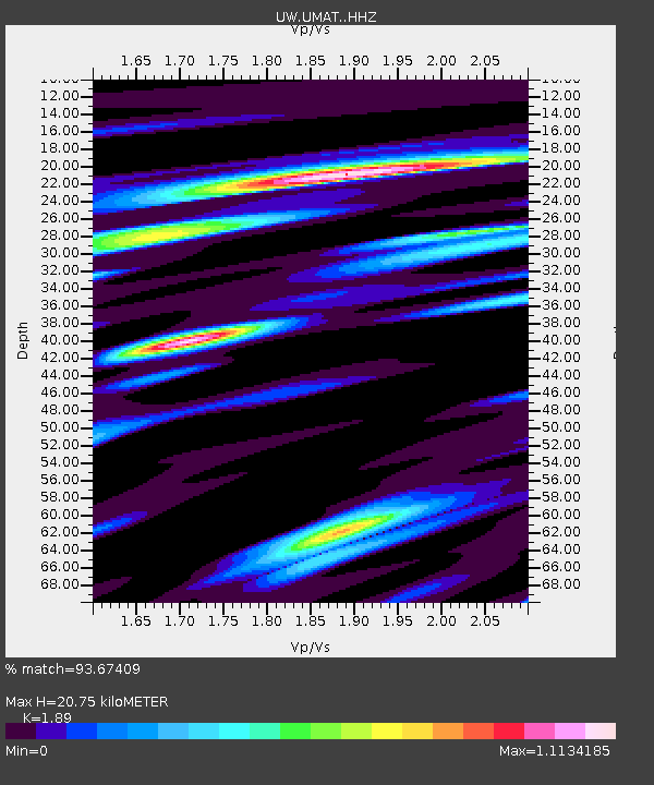
| Estimated Moho Depth: |
20.75 km |
| Estimated Crust Vp/Vs: |
1.89 |
| Assumed Crust Vp: |
6.571 km/s |
| Estimated Crust Vs: |
3.477 km/s |
| Estimated Crust Poisson's Ratio: |
0.31 |
|
| Radial Match: |
93.67409 % |
| Radial Bump: |
382 |
| Transverse Match: |
84.21272 % |
| Transverse Bump: |
400 |
| SOD ConfigId: |
26694651 |
| Insert Time: |
2021-12-12 11:33:22.128 +0000 |
| GWidth: |
2.5 |
| Max Bumps: |
400 |
| Tol: |
0.001 |
|
Signal To Noise
| Channel | StoN | STA | LTA |
| UW:UMAT: :HHZ:20211128T11:01:54.659973Z | 7.7608237 | 4.600751E-6 | 5.9281734E-7 |
| UW:UMAT: :HHN:20211128T11:01:54.659973Z | 4.0574365 | 1.5671221E-6 | 3.8623452E-7 |
| UW:UMAT: :HHE:20211128T11:01:54.659973Z | 4.8954773 | 2.1611909E-6 | 4.4146685E-7 |
| Arrivals |
| Ps | 2.9 SECOND |
| PpPs | 8.7 SECOND |
| PsPs/PpSs | 12 SECOND |


