You are here: Home > Network List > UW - Pacific Northwest Regional Seismic Network Stations List
> Station BHAM Bellingham, WA, USA > Earthquake Result Viewer
BHAM Bellingham, WA, USA - Earthquake Result Viewer
| Earthquake location: |
Northern Peru |
| Earthquake latitude/longitude: |
-4.5/-76.7 |
| Earthquake time(UTC): |
2021/11/28 (332) 10:52:14 GMT |
| Earthquake Depth: |
99 km |
| Earthquake Magnitude: |
7.4 Mi |
| Earthquake Catalog/Contributor: |
NEIC PDE/at |
|
| Network: |
UW Pacific Northwest Regional Seismic Network |
| Station: |
BHAM Bellingham, WA, USA |
| Lat/Lon: |
48.79 N/122.42 W |
| Elevation: |
116 m |
|
| Distance: |
66.3 deg |
| Az: |
328.864 deg |
| Baz: |
128.79 deg |
| Ray Param: |
0.057448283 |
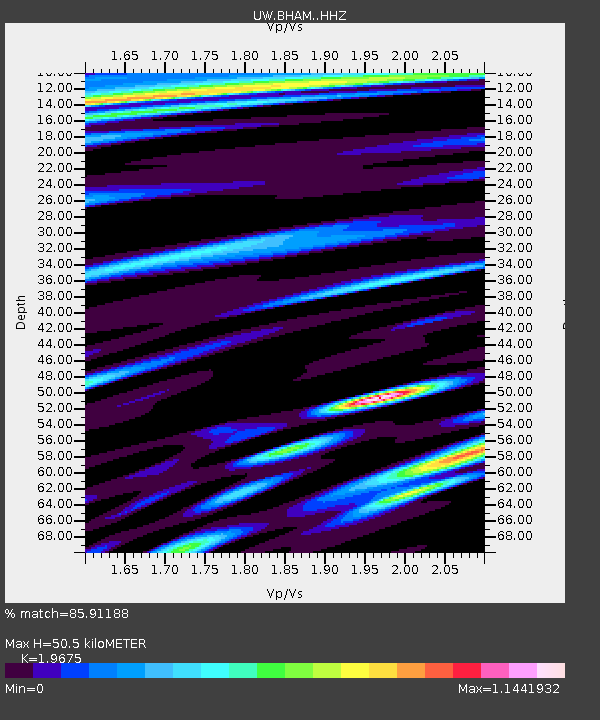
| Estimated Moho Depth: |
50.5 km |
| Estimated Crust Vp/Vs: |
1.97 |
| Assumed Crust Vp: |
6.566 km/s |
| Estimated Crust Vs: |
3.337 km/s |
| Estimated Crust Poisson's Ratio: |
0.33 |
|
| Radial Match: |
85.91188 % |
| Radial Bump: |
400 |
| Transverse Match: |
84.85125 % |
| Transverse Bump: |
400 |
| SOD ConfigId: |
26694651 |
| Insert Time: |
2021-12-12 11:33:53.545 +0000 |
| GWidth: |
2.5 |
| Max Bumps: |
400 |
| Tol: |
0.001 |
|

Signal To Noise
| Channel | StoN | STA | LTA |
| UW:BHAM: :HHZ:20211128T11:02:21.059998Z | 7.237912 | 5.2968003E-6 | 7.3181326E-7 |
| UW:BHAM: :HHN:20211128T11:02:21.059998Z | 2.4724023 | 1.6216495E-6 | 6.559003E-7 |
| UW:BHAM: :HHE:20211128T11:02:21.059998Z | 2.4459007 | 2.3951554E-6 | 9.792528E-7 |
| Arrivals |
| Ps | 7.7 SECOND |
| PpPs | 22 SECOND |
| PsPs/PpSs | 30 SECOND |


