You are here: Home > Network List > YN10 - San Jacinto Fault Zone Stations List
> Station JORD JORD > Earthquake Result Viewer
JORD JORD - Earthquake Result Viewer
| Earthquake location: |
Northern Peru |
| Earthquake latitude/longitude: |
-4.5/-76.7 |
| Earthquake time(UTC): |
2021/11/28 (332) 10:52:14 GMT |
| Earthquake Depth: |
99 km |
| Earthquake Magnitude: |
7.4 Mi |
| Earthquake Catalog/Contributor: |
NEIC PDE/at |
|
| Network: |
YN San Jacinto Fault Zone |
| Station: |
JORD JORD |
| Lat/Lon: |
33.47 N/116.64 W |
| Elevation: |
1235 m |
|
| Distance: |
53.4 deg |
| Az: |
318.058 deg |
| Baz: |
127.135 deg |
| Ray Param: |
0.06580836 |
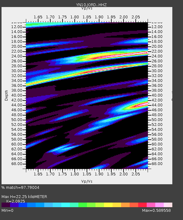
| Estimated Moho Depth: |
22.25 km |
| Estimated Crust Vp/Vs: |
2.09 |
| Assumed Crust Vp: |
6.264 km/s |
| Estimated Crust Vs: |
2.993 km/s |
| Estimated Crust Poisson's Ratio: |
0.35 |
|
| Radial Match: |
97.79004 % |
| Radial Bump: |
336 |
| Transverse Match: |
84.29084 % |
| Transverse Bump: |
400 |
| SOD ConfigId: |
26694651 |
| Insert Time: |
2021-12-12 11:35:18.664 +0000 |
| GWidth: |
2.5 |
| Max Bumps: |
400 |
| Tol: |
0.001 |
|

Signal To Noise
| Channel | StoN | STA | LTA |
| YN:JORD: :HHZ:20211128T11:00:52.999023Z | 16.449978 | 4.011195E-6 | 2.4384198E-7 |
| YN:JORD: :HHN:20211128T11:00:52.999023Z | 4.4549623 | 1.357772E-6 | 3.0477747E-7 |
| YN:JORD: :HHE:20211128T11:00:52.999023Z | 7.5507836 | 1.8855455E-6 | 2.497152E-7 |
| Arrivals |
| Ps | 4.1 SECOND |
| PpPs | 11 SECOND |
| PsPs/PpSs | 15 SECOND |


