You are here: Home > Network List > YX16 - Raton Basin UNM Broadband Network Stations List
> Station UNM5 Southernmost CO Station > Earthquake Result Viewer
UNM5 Southernmost CO Station - Earthquake Result Viewer
| Earthquake location: |
Northern Peru |
| Earthquake latitude/longitude: |
-4.5/-76.7 |
| Earthquake time(UTC): |
2021/11/28 (332) 10:52:14 GMT |
| Earthquake Depth: |
99 km |
| Earthquake Magnitude: |
7.4 Mi |
| Earthquake Catalog/Contributor: |
NEIC PDE/at |
|
| Network: |
YX Raton Basin UNM Broadband Network |
| Station: |
UNM5 Southernmost CO Station |
| Lat/Lon: |
37.12 N/104.78 W |
| Elevation: |
2035 m |
|
| Distance: |
49.0 deg |
| Az: |
330.089 deg |
| Baz: |
141.54 deg |
| Ray Param: |
0.06868691 |
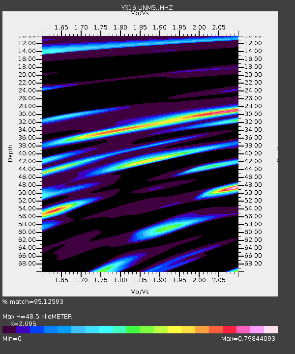
| Estimated Moho Depth: |
48.5 km |
| Estimated Crust Vp/Vs: |
2.10 |
| Assumed Crust Vp: |
6.316 km/s |
| Estimated Crust Vs: |
3.015 km/s |
| Estimated Crust Poisson's Ratio: |
0.35 |
|
| Radial Match: |
95.12593 % |
| Radial Bump: |
400 |
| Transverse Match: |
87.17749 % |
| Transverse Bump: |
400 |
| SOD ConfigId: |
26694651 |
| Insert Time: |
2021-12-12 11:35:25.414 +0000 |
| GWidth: |
2.5 |
| Max Bumps: |
400 |
| Tol: |
0.001 |
|

Signal To Noise
| Channel | StoN | STA | LTA |
| YX:UNM5: :HHZ:20211128T11:00:20.019012Z | 13.893195 | 5.289333E-6 | 3.807139E-7 |
| YX:UNM5: :HHN:20211128T11:00:20.019012Z | 5.094205 | 1.8858142E-6 | 3.7018813E-7 |
| YX:UNM5: :HHE:20211128T11:00:20.019012Z | 5.828524 | 2.0522775E-6 | 3.5210928E-7 |
| Arrivals |
| Ps | 8.8 SECOND |
| PpPs | 23 SECOND |
| PsPs/PpSs | 31 SECOND |


