You are here: Home > Network List > AK - Alaska Regional Network Stations List
> Station D20K Etivluk River, AK, USA > Earthquake Result Viewer
D20K Etivluk River, AK, USA - Earthquake Result Viewer
| Earthquake location: |
Southeast Of Honshu, Japan |
| Earthquake latitude/longitude: |
31.1/142.8 |
| Earthquake time(UTC): |
2021/11/29 (333) 12:40:43 GMT |
| Earthquake Depth: |
10 km |
| Earthquake Magnitude: |
6.6 Mi |
| Earthquake Catalog/Contributor: |
NEIC PDE/pt |
|
| Network: |
AK Alaska Regional Network |
| Station: |
D20K Etivluk River, AK, USA |
| Lat/Lon: |
68.71 N/156.61 W |
| Elevation: |
577 m |
|
| Distance: |
50.8 deg |
| Az: |
24.242 deg |
| Baz: |
254.695 deg |
| Ray Param: |
0.0678275 |
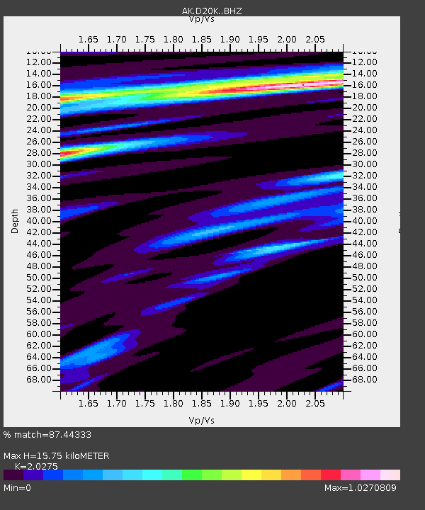
| Estimated Moho Depth: |
15.75 km |
| Estimated Crust Vp/Vs: |
2.03 |
| Assumed Crust Vp: |
6.221 km/s |
| Estimated Crust Vs: |
3.068 km/s |
| Estimated Crust Poisson's Ratio: |
0.34 |
|
| Radial Match: |
87.44333 % |
| Radial Bump: |
392 |
| Transverse Match: |
78.92437 % |
| Transverse Bump: |
400 |
| SOD ConfigId: |
26694651 |
| Insert Time: |
2021-12-13 12:42:45.494 +0000 |
| GWidth: |
2.5 |
| Max Bumps: |
400 |
| Tol: |
0.001 |
|

Signal To Noise
| Channel | StoN | STA | LTA |
| AK:D20K: :BHZ:20211129T12:49:12.26001Z | 3.9054022 | 6.564459E-7 | 1.6808663E-7 |
| AK:D20K: :BHN:20211129T12:49:12.26001Z | 0.70955706 | 1.14012195E-7 | 1.606808E-7 |
| AK:D20K: :BHE:20211129T12:49:12.26001Z | 1.8845611 | 3.519335E-7 | 1.8674561E-7 |
| Arrivals |
| Ps | 2.7 SECOND |
| PpPs | 7.3 SECOND |
| PsPs/PpSs | 10 SECOND |


