You are here: Home > Network List > AK - Alaska Regional Network Stations List
> Station WAT1 Susitna Watana 1, AK, USA > Earthquake Result Viewer
WAT1 Susitna Watana 1, AK, USA - Earthquake Result Viewer
| Earthquake location: |
Southeast Of Honshu, Japan |
| Earthquake latitude/longitude: |
31.1/142.8 |
| Earthquake time(UTC): |
2021/11/29 (333) 12:40:43 GMT |
| Earthquake Depth: |
10 km |
| Earthquake Magnitude: |
6.6 Mi |
| Earthquake Catalog/Contributor: |
NEIC PDE/pt |
|
| Network: |
AK Alaska Regional Network |
| Station: |
WAT1 Susitna Watana 1, AK, USA |
| Lat/Lon: |
62.83 N/148.55 W |
| Elevation: |
722 m |
|
| Distance: |
53.1 deg |
| Az: |
32.307 deg |
| Baz: |
267.027 deg |
| Ray Param: |
0.066319354 |
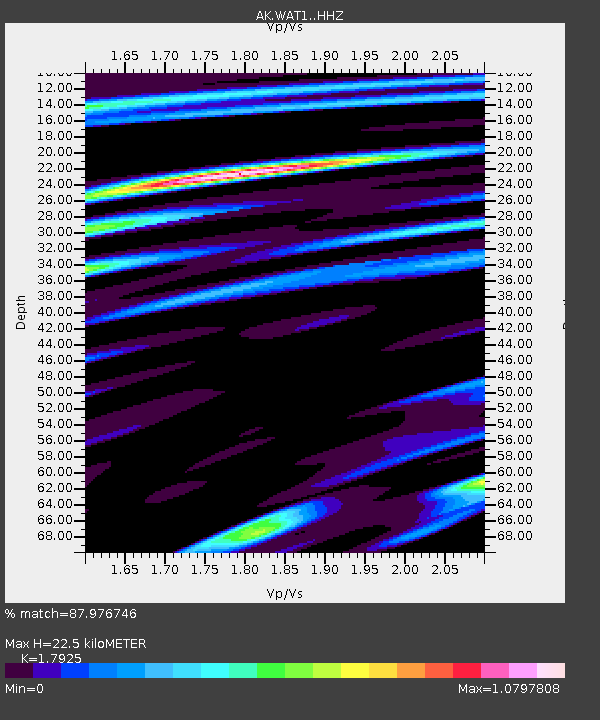
| Estimated Moho Depth: |
22.5 km |
| Estimated Crust Vp/Vs: |
1.79 |
| Assumed Crust Vp: |
6.566 km/s |
| Estimated Crust Vs: |
3.663 km/s |
| Estimated Crust Poisson's Ratio: |
0.27 |
|
| Radial Match: |
87.976746 % |
| Radial Bump: |
400 |
| Transverse Match: |
72.53571 % |
| Transverse Bump: |
400 |
| SOD ConfigId: |
26694651 |
| Insert Time: |
2021-12-13 12:44:34.021 +0000 |
| GWidth: |
2.5 |
| Max Bumps: |
400 |
| Tol: |
0.001 |
|

Signal To Noise
| Channel | StoN | STA | LTA |
| AK:WAT1: :HHZ:20211129T12:49:29.757996Z | 6.3340783 | 1.2282834E-6 | 1.9391666E-7 |
| AK:WAT1: :HHN:20211129T12:49:29.757996Z | 0.73782706 | 2.9695718E-7 | 4.0247534E-7 |
| AK:WAT1: :HHE:20211129T12:49:29.757996Z | 2.55114 | 5.741781E-7 | 2.2506725E-7 |
| Arrivals |
| Ps | 2.9 SECOND |
| PpPs | 9.0 SECOND |
| PsPs/PpSs | 12 SECOND |


