You are here: Home > Network List > YL01 - Himalayan Nepal Tibet Experiment Stations List
> Station SIND YL.SIND > Earthquake Result Viewer
SIND YL.SIND - Earthquake Result Viewer
| Earthquake location: |
Northeastern China |
| Earthquake latitude/longitude: |
44.8/129.9 |
| Earthquake time(UTC): |
2002/09/15 (258) 08:39:32 GMT |
| Earthquake Depth: |
586 km |
| Earthquake Magnitude: |
5.8 MB, 6.4 MW, 6.4 MW |
| Earthquake Catalog/Contributor: |
WHDF/NEIC |
|
| Network: |
YL Himalayan Nepal Tibet Experiment |
| Station: |
SIND YL.SIND |
| Lat/Lon: |
27.21 N/85.91 E |
| Elevation: |
465 m |
|
| Distance: |
39.2 deg |
| Az: |
258.455 deg |
| Baz: |
51.517 deg |
| Ray Param: |
0.07211309 |
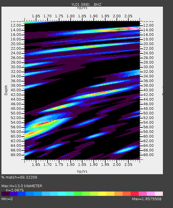
| Estimated Moho Depth: |
13.0 km |
| Estimated Crust Vp/Vs: |
2.10 |
| Assumed Crust Vp: |
6.142 km/s |
| Estimated Crust Vs: |
2.928 km/s |
| Estimated Crust Poisson's Ratio: |
0.35 |
|
| Radial Match: |
88.32208 % |
| Radial Bump: |
400 |
| Transverse Match: |
80.63903 % |
| Transverse Bump: |
400 |
| SOD ConfigId: |
16844 |
| Insert Time: |
2010-02-26 16:12:07.289 +0000 |
| GWidth: |
2.5 |
| Max Bumps: |
400 |
| Tol: |
0.001 |
|
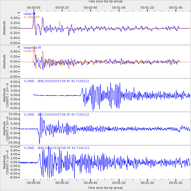
Signal To Noise
| Channel | StoN | STA | LTA |
| YL:SIND: :BHZ:20020915T08:45:40.719012Z | 51.14329 | 5.642857E-6 | 1.1033426E-7 |
| YL:SIND: :BHN:20020915T08:45:40.719012Z | 11.343473 | 1.4152325E-6 | 1.2476183E-7 |
| YL:SIND: :BHE:20020915T08:45:40.719012Z | 11.287436 | 1.6064425E-6 | 1.4232131E-7 |
| Arrivals |
| Ps | 2.4 SECOND |
| PpPs | 6.2 SECOND |
| PsPs/PpSs | 8.7 SECOND |


