You are here: Home > Network List > AU - Australian Seismological Centre Stations List
> Station KIM04 GSWA station > Earthquake Result Viewer
KIM04 GSWA station - Earthquake Result Viewer
| Earthquake location: |
Southeast Of Honshu, Japan |
| Earthquake latitude/longitude: |
31.1/142.8 |
| Earthquake time(UTC): |
2021/11/29 (333) 12:40:43 GMT |
| Earthquake Depth: |
10 km |
| Earthquake Magnitude: |
6.6 Mi |
| Earthquake Catalog/Contributor: |
NEIC PDE/pt |
|
| Network: |
AU Australian Seismological Centre |
| Station: |
KIM04 GSWA station |
| Lat/Lon: |
17.93 S/124.81 E |
| Elevation: |
133 m |
|
| Distance: |
51.7 deg |
| Az: |
201.997 deg |
| Baz: |
19.723 deg |
| Ray Param: |
0.06723286 |
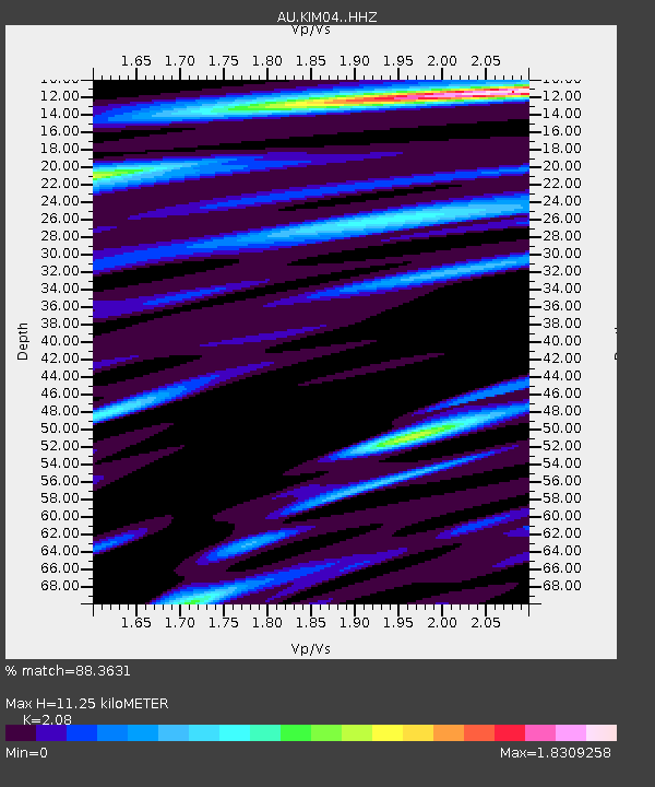
| Estimated Moho Depth: |
11.25 km |
| Estimated Crust Vp/Vs: |
2.08 |
| Assumed Crust Vp: |
6.496 km/s |
| Estimated Crust Vs: |
3.123 km/s |
| Estimated Crust Poisson's Ratio: |
0.35 |
|
| Radial Match: |
88.3631 % |
| Radial Bump: |
400 |
| Transverse Match: |
59.263214 % |
| Transverse Bump: |
400 |
| SOD ConfigId: |
26694651 |
| Insert Time: |
2021-12-13 12:45:53.622 +0000 |
| GWidth: |
2.5 |
| Max Bumps: |
400 |
| Tol: |
0.001 |
|

Signal To Noise
| Channel | StoN | STA | LTA |
| AU:KIM04: :HHZ:20211129T12:49:19.325012Z | 7.577139 | 1.3197729E-4 | 1.7417826E-5 |
| AU:KIM04: :HHN:20211129T12:49:19.325012Z | 2.245624 | 4.4595497E-5 | 1.9858844E-5 |
| AU:KIM04: :HHE:20211129T12:49:19.325012Z | 0.9836881 | 2.2665781E-5 | 2.3041634E-5 |
| Arrivals |
| Ps | 2.0 SECOND |
| PpPs | 5.1 SECOND |
| PsPs/PpSs | 7.0 SECOND |


