You are here: Home > Network List > AV - Alaska Volcano Observatory Stations List
> Station SPCG Capps Glacier, Mount Spurr, Alaska > Earthquake Result Viewer
SPCG Capps Glacier, Mount Spurr, Alaska - Earthquake Result Viewer
| Earthquake location: |
Southeast Of Honshu, Japan |
| Earthquake latitude/longitude: |
31.1/142.8 |
| Earthquake time(UTC): |
2021/11/29 (333) 12:40:43 GMT |
| Earthquake Depth: |
10 km |
| Earthquake Magnitude: |
6.6 Mi |
| Earthquake Catalog/Contributor: |
NEIC PDE/pt |
|
| Network: |
AV Alaska Volcano Observatory |
| Station: |
SPCG Capps Glacier, Mount Spurr, Alaska |
| Lat/Lon: |
61.29 N/152.02 W |
| Elevation: |
1329 m |
|
| Distance: |
51.4 deg |
| Az: |
34.111 deg |
| Baz: |
265.07 deg |
| Ray Param: |
0.06744604 |
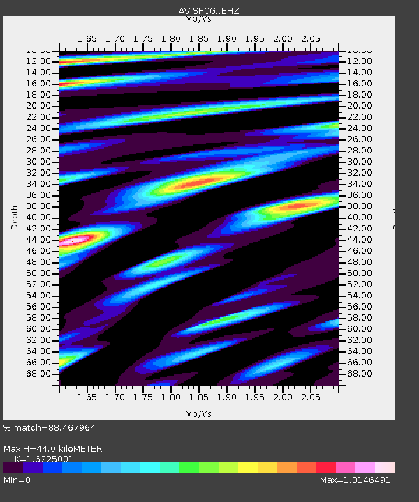
| Estimated Moho Depth: |
44.0 km |
| Estimated Crust Vp/Vs: |
1.62 |
| Assumed Crust Vp: |
6.566 km/s |
| Estimated Crust Vs: |
4.047 km/s |
| Estimated Crust Poisson's Ratio: |
0.19 |
|
| Radial Match: |
88.467964 % |
| Radial Bump: |
400 |
| Transverse Match: |
82.94071 % |
| Transverse Bump: |
400 |
| SOD ConfigId: |
26694651 |
| Insert Time: |
2021-12-13 12:47:18.165 +0000 |
| GWidth: |
2.5 |
| Max Bumps: |
400 |
| Tol: |
0.001 |
|

Signal To Noise
| Channel | StoN | STA | LTA |
| AV:SPCG: :BHZ:20211129T12:49:16.859985Z | 2.4083312 | 3.816044E-7 | 1.584518E-7 |
| AV:SPCG: :BHN:20211129T12:49:16.859985Z | 1.1206572 | 3.6634606E-7 | 3.2690286E-7 |
| AV:SPCG: :BHE:20211129T12:49:16.859985Z | 1.5686066 | 2.47254E-7 | 1.5762653E-7 |
| Arrivals |
| Ps | 4.5 SECOND |
| PpPs | 16 SECOND |
| PsPs/PpSs | 21 SECOND |


