You are here: Home > Network List > CN - Canadian National Seismograph Network Stations List
> Station INK INUVIK, NT > Earthquake Result Viewer
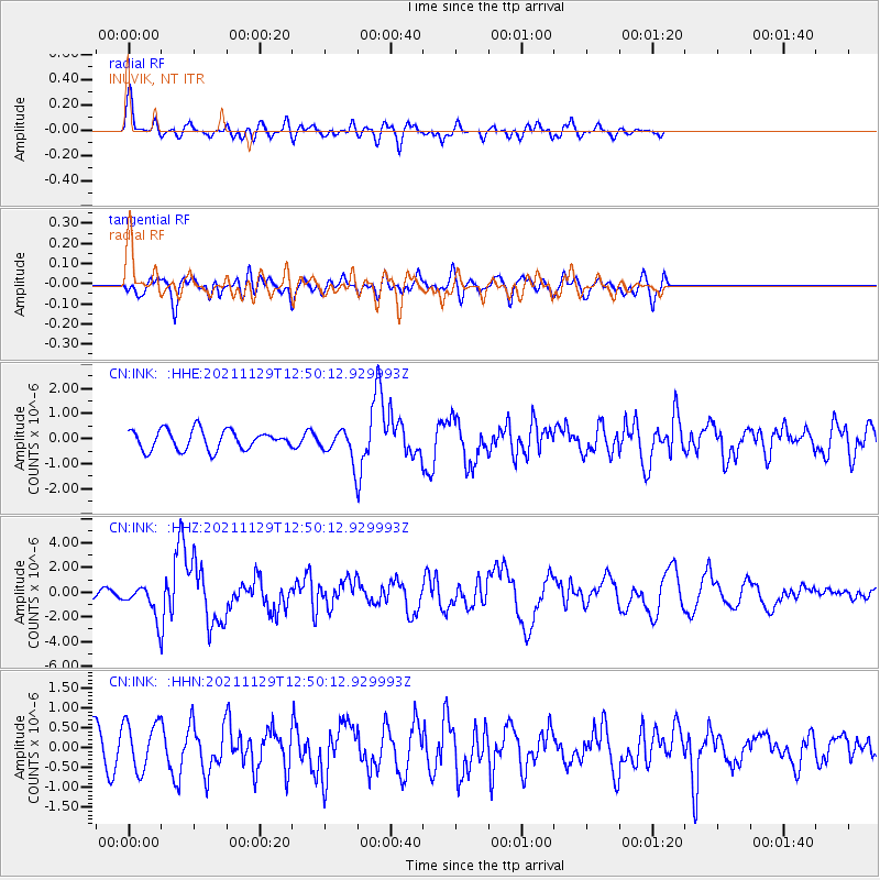
INK INUVIK, NT - Earthquake Result Viewer
*The percent match for this event was below the threshold and hence no stack was calculated.
| Earthquake location: |
Southeast Of Honshu, Japan |
| Earthquake latitude/longitude: |
31.1/142.8 |
| Earthquake time(UTC): |
2021/11/29 (333) 12:40:43 GMT |
| Earthquake Depth: |
10 km |
| Earthquake Magnitude: |
6.6 Mi |
| Earthquake Catalog/Contributor: |
NEIC PDE/pt |
|
| Network: |
CN Canadian National Seismograph Network |
| Station: |
INK INUVIK, NT |
| Lat/Lon: |
68.31 N/133.53 W |
| Elevation: |
44 m |
|
| Distance: |
59.2 deg |
| Az: |
25.485 deg |
| Baz: |
276.913 deg |
| Ray Param: |
$rayparam |
*The percent match for this event was below the threshold and hence was not used in the summary stack. |
|
| Radial Match: |
77.297104 % |
| Radial Bump: |
400 |
| Transverse Match: |
60.89435 % |
| Transverse Bump: |
400 |
| SOD ConfigId: |
26694651 |
| Insert Time: |
2021-12-13 12:51:05.125 +0000 |
| GWidth: |
2.5 |
| Max Bumps: |
400 |
| Tol: |
0.001 |
|
Signal To Noise
| Channel | StoN | STA | LTA |
| CN:INK: :HHZ:20211129T12:50:12.929993Z | 2.6445658 | 1.2190674E-6 | 4.609707E-7 |
| CN:INK: :HHN:20211129T12:50:12.929993Z | 1.472658 | 6.0763364E-7 | 4.1261015E-7 |
| CN:INK: :HHE:20211129T12:50:12.929993Z | 1.481098 | 5.7726163E-7 | 3.8975244E-7 |
| Arrivals |
| Ps | |
| PpPs | |
| PsPs/PpSs | |


