You are here: Home > Network List > YL01 - Himalayan Nepal Tibet Experiment Stations List
> Station SIND YL.SIND > Earthquake Result Viewer
SIND YL.SIND - Earthquake Result Viewer
| Earthquake location: |
Hokkaido, Japan Region |
| Earthquake latitude/longitude: |
41.2/142.2 |
| Earthquake time(UTC): |
2002/10/14 (287) 14:12:43 GMT |
| Earthquake Depth: |
61 km |
| Earthquake Magnitude: |
5.9 MB, 6.1 MW, 6.1 MW |
| Earthquake Catalog/Contributor: |
WHDF/NEIC |
|
| Network: |
YL Himalayan Nepal Tibet Experiment |
| Station: |
SIND YL.SIND |
| Lat/Lon: |
27.21 N/85.91 E |
| Elevation: |
465 m |
|
| Distance: |
47.9 deg |
| Az: |
271.517 deg |
| Baz: |
57.925 deg |
| Ray Param: |
0.069553114 |
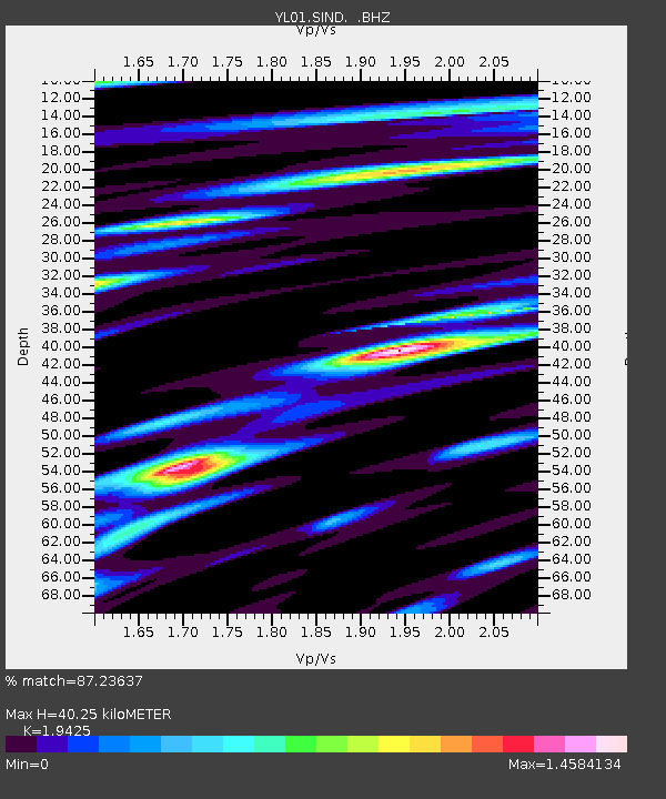
| Estimated Moho Depth: |
40.25 km |
| Estimated Crust Vp/Vs: |
1.94 |
| Assumed Crust Vp: |
6.142 km/s |
| Estimated Crust Vs: |
3.162 km/s |
| Estimated Crust Poisson's Ratio: |
0.32 |
|
| Radial Match: |
87.23637 % |
| Radial Bump: |
400 |
| Transverse Match: |
84.55623 % |
| Transverse Bump: |
400 |
| SOD ConfigId: |
16844 |
| Insert Time: |
2010-02-26 16:12:10.658 +0000 |
| GWidth: |
2.5 |
| Max Bumps: |
400 |
| Tol: |
0.001 |
|

Signal To Noise
| Channel | StoN | STA | LTA |
| YL:SIND: :BHZ:20021014T14:20:44.980011Z | 21.73796 | 2.8153681E-6 | 1.295139E-7 |
| YL:SIND: :BHN:20021014T14:20:44.980011Z | 7.45121 | 7.5958764E-7 | 1.0194151E-7 |
| YL:SIND: :BHE:20021014T14:20:44.980011Z | 9.942772 | 1.0914089E-6 | 1.0976908E-7 |
| Arrivals |
| Ps | 6.5 SECOND |
| PpPs | 18 SECOND |
| PsPs/PpSs | 25 SECOND |


