You are here: Home > Network List > KO - Kandilli Observatory Digital Broadband Seismic Network Stations List
> Station GAZ Gaziantep-Turkey > Earthquake Result Viewer
GAZ Gaziantep-Turkey - Earthquake Result Viewer
| Earthquake location: |
Southeast Of Honshu, Japan |
| Earthquake latitude/longitude: |
31.1/142.8 |
| Earthquake time(UTC): |
2021/11/29 (333) 12:40:43 GMT |
| Earthquake Depth: |
10 km |
| Earthquake Magnitude: |
6.6 Mi |
| Earthquake Catalog/Contributor: |
NEIC PDE/pt |
|
| Network: |
KO Kandilli Observatory Digital Broadband Seismic Network |
| Station: |
GAZ Gaziantep-Turkey |
| Lat/Lon: |
37.17 N/37.21 E |
| Elevation: |
992 m |
|
| Distance: |
82.8 deg |
| Az: |
309.152 deg |
| Baz: |
56.385 deg |
| Ray Param: |
0.046631493 |
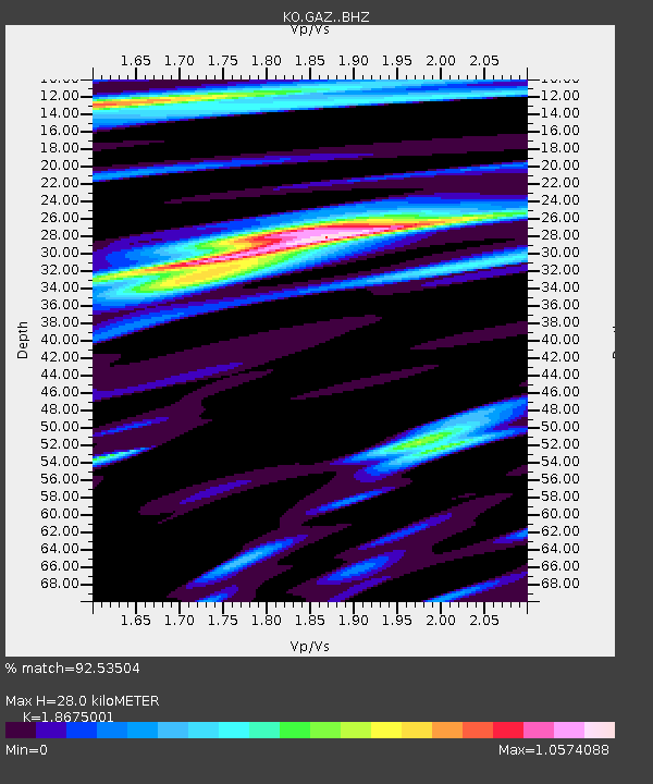
| Estimated Moho Depth: |
28.0 km |
| Estimated Crust Vp/Vs: |
1.87 |
| Assumed Crust Vp: |
6.247 km/s |
| Estimated Crust Vs: |
3.345 km/s |
| Estimated Crust Poisson's Ratio: |
0.30 |
|
| Radial Match: |
92.53504 % |
| Radial Bump: |
400 |
| Transverse Match: |
83.63517 % |
| Transverse Bump: |
400 |
| SOD ConfigId: |
26694651 |
| Insert Time: |
2021-12-13 12:55:19.968 +0000 |
| GWidth: |
2.5 |
| Max Bumps: |
400 |
| Tol: |
0.001 |
|

Signal To Noise
| Channel | StoN | STA | LTA |
| KO:GAZ: :BHZ:20211129T12:52:35.880005Z | 31.322674 | 2.3952273E-6 | 7.646944E-8 |
| KO:GAZ: :BHN:20211129T12:52:35.880005Z | 4.2756486 | 3.425434E-7 | 8.011496E-8 |
| KO:GAZ: :BHE:20211129T12:52:35.880005Z | 7.3861146 | 5.0428577E-7 | 6.827484E-8 |
| Arrivals |
| Ps | 4.0 SECOND |
| PpPs | 13 SECOND |
| PsPs/PpSs | 17 SECOND |


