You are here: Home > Network List > YL01 - Himalayan Nepal Tibet Experiment Stations List
> Station SIND YL.SIND > Earthquake Result Viewer
SIND YL.SIND - Earthquake Result Viewer
| Earthquake location: |
Near East Coast Of Kamchatka |
| Earthquake latitude/longitude: |
52.0/157.3 |
| Earthquake time(UTC): |
2002/10/16 (289) 10:12:21 GMT |
| Earthquake Depth: |
102 km |
| Earthquake Magnitude: |
6.1 MB, 6.2 MW, 6.2 MW |
| Earthquake Catalog/Contributor: |
WHDF/NEIC |
|
| Network: |
YL Himalayan Nepal Tibet Experiment |
| Station: |
SIND YL.SIND |
| Lat/Lon: |
27.21 N/85.91 E |
| Elevation: |
465 m |
|
| Distance: |
57.8 deg |
| Az: |
273.967 deg |
| Baz: |
43.889 deg |
| Ray Param: |
0.06296194 |
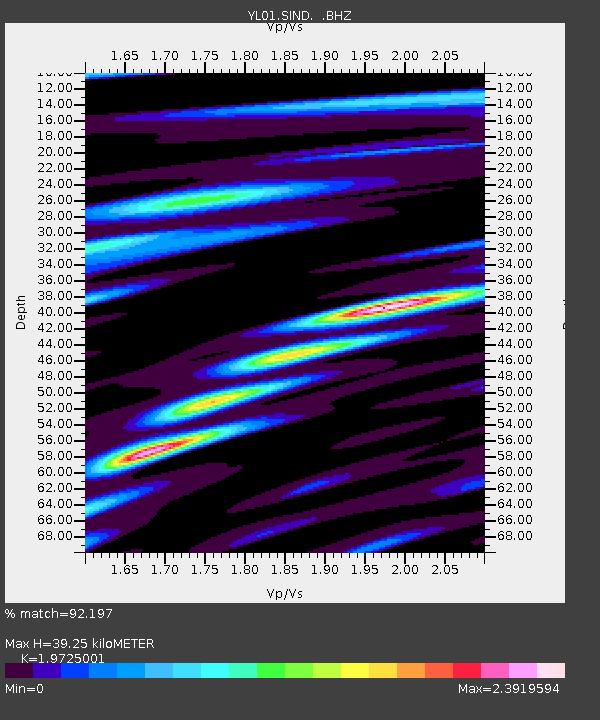
| Estimated Moho Depth: |
39.25 km |
| Estimated Crust Vp/Vs: |
1.97 |
| Assumed Crust Vp: |
6.142 km/s |
| Estimated Crust Vs: |
3.114 km/s |
| Estimated Crust Poisson's Ratio: |
0.33 |
|
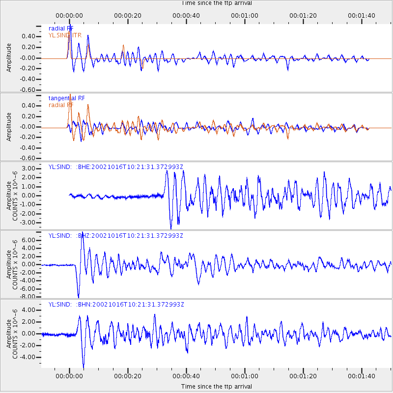
| Radial Match: |
92.197 % |
| Radial Bump: |
400 |
| Transverse Match: |
89.44522 % |
| Transverse Bump: |
400 |
| SOD ConfigId: |
16844 |
| Insert Time: |
2010-02-26 16:12:12.043 +0000 |
| GWidth: |
2.5 |
| Max Bumps: |
400 |
| Tol: |
0.001 |
|
Signal To Noise
| Channel | StoN | STA | LTA |
| YL:SIND: :BHZ:20021016T10:21:31.372993Z | 45.8295 | 3.92592E-6 | 8.56636E-8 |
| YL:SIND: :BHN:20021016T10:21:31.372993Z | 19.479029 | 1.8047493E-6 | 9.2650886E-8 |
| YL:SIND: :BHE:20021016T10:21:31.372993Z | 12.049736 | 1.4394183E-6 | 1.194564E-7 |
| Arrivals |
| Ps | 6.5 SECOND |
| PpPs | 18 SECOND |
| PsPs/PpSs | 25 SECOND |


