You are here: Home > Network List > NK - Nepal Kathmandu (NK) Stations List
> Station KKN Kakani, Nepal > Earthquake Result Viewer
KKN Kakani, Nepal - Earthquake Result Viewer
| Earthquake location: |
Southeast Of Honshu, Japan |
| Earthquake latitude/longitude: |
31.1/142.8 |
| Earthquake time(UTC): |
2021/11/29 (333) 12:40:43 GMT |
| Earthquake Depth: |
10 km |
| Earthquake Magnitude: |
6.6 Mi |
| Earthquake Catalog/Contributor: |
NEIC PDE/pt |
|
| Network: |
NK Nepal Kathmandu (NK) |
| Station: |
KKN Kakani, Nepal |
| Lat/Lon: |
27.80 N/85.28 E |
| Elevation: |
2042 m |
|
| Distance: |
49.7 deg |
| Az: |
281.604 deg |
| Baz: |
71.535 deg |
| Ray Param: |
0.068536334 |
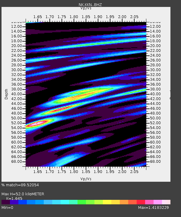
| Estimated Moho Depth: |
52.0 km |
| Estimated Crust Vp/Vs: |
1.64 |
| Assumed Crust Vp: |
6.142 km/s |
| Estimated Crust Vs: |
3.734 km/s |
| Estimated Crust Poisson's Ratio: |
0.21 |
|
| Radial Match: |
89.52054 % |
| Radial Bump: |
400 |
| Transverse Match: |
84.70277 % |
| Transverse Bump: |
400 |
| SOD ConfigId: |
26694651 |
| Insert Time: |
2021-12-13 12:57:35.561 +0000 |
| GWidth: |
2.5 |
| Max Bumps: |
400 |
| Tol: |
0.001 |
|

Signal To Noise
| Channel | StoN | STA | LTA |
| NK:KKN: :BHZ:20211129T12:49:04.26001Z | 18.681793 | 1.5771552E-6 | 8.442205E-8 |
| NK:KKN: :BHN:20211129T12:49:04.26001Z | 4.0720286 | 3.145245E-7 | 7.7240244E-8 |
| NK:KKN: :BHE:20211129T12:49:04.26001Z | 9.725036 | 7.4998246E-7 | 7.7118735E-8 |
| Arrivals |
| Ps | 5.8 SECOND |
| PpPs | 21 SECOND |
| PsPs/PpSs | 27 SECOND |


