You are here: Home > Network List > US - United States National Seismic Network Stations List
> Station HAWA Hanford, Washington, USA > Earthquake Result Viewer
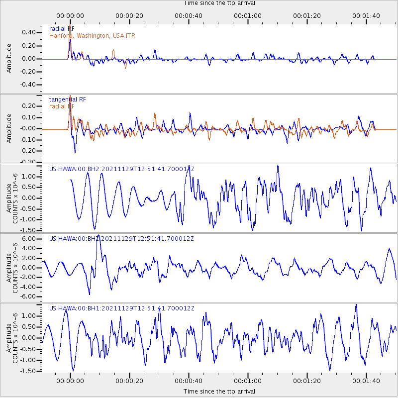
HAWA Hanford, Washington, USA - Earthquake Result Viewer
*The percent match for this event was below the threshold and hence no stack was calculated.
| Earthquake location: |
Southeast Of Honshu, Japan |
| Earthquake latitude/longitude: |
31.1/142.8 |
| Earthquake time(UTC): |
2021/11/29 (333) 12:40:43 GMT |
| Earthquake Depth: |
10 km |
| Earthquake Magnitude: |
6.6 Mi |
| Earthquake Catalog/Contributor: |
NEIC PDE/pt |
|
| Network: |
US United States National Seismic Network |
| Station: |
HAWA Hanford, Washington, USA |
| Lat/Lon: |
46.39 N/119.53 W |
| Elevation: |
364 m |
|
| Distance: |
73.0 deg |
| Az: |
45.82 deg |
| Baz: |
297.277 deg |
| Ray Param: |
$rayparam |
*The percent match for this event was below the threshold and hence was not used in the summary stack. |
|
| Radial Match: |
62.80046 % |
| Radial Bump: |
400 |
| Transverse Match: |
61.857204 % |
| Transverse Bump: |
400 |
| SOD ConfigId: |
26694651 |
| Insert Time: |
2021-12-13 13:07:51.442 +0000 |
| GWidth: |
2.5 |
| Max Bumps: |
400 |
| Tol: |
0.001 |
|
Signal To Noise
| Channel | StoN | STA | LTA |
| US:HAWA:00:BHZ:20211129T12:51:41.700012Z | 1.2486491 | 9.092875E-7 | 7.2821695E-7 |
| US:HAWA:00:BH1:20211129T12:51:41.700012Z | 2.3919854 | 8.174523E-7 | 3.4174636E-7 |
| US:HAWA:00:BH2:20211129T12:51:41.700012Z | 0.41527578 | 2.7623048E-7 | 6.6517356E-7 |
| Arrivals |
| Ps | |
| PpPs | |
| PsPs/PpSs | |


