You are here: Home > Network List > US - United States National Seismic Network Stations List
> Station MNTX Cornudas Mountains, Texas, USA > Earthquake Result Viewer
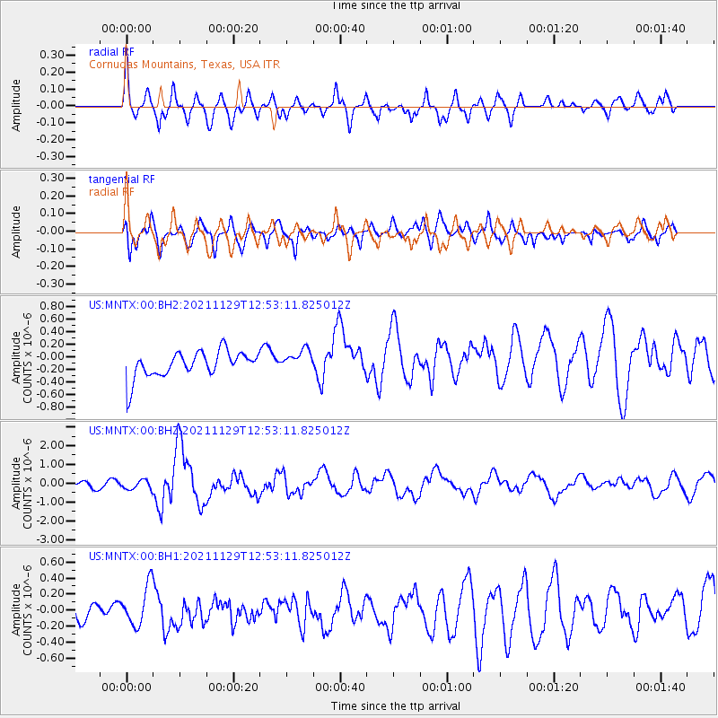
MNTX Cornudas Mountains, Texas, USA - Earthquake Result Viewer
*The percent match for this event was below the threshold and hence no stack was calculated.
| Earthquake location: |
Southeast Of Honshu, Japan |
| Earthquake latitude/longitude: |
31.1/142.8 |
| Earthquake time(UTC): |
2021/11/29 (333) 12:40:43 GMT |
| Earthquake Depth: |
10 km |
| Earthquake Magnitude: |
6.6 Mi |
| Earthquake Catalog/Contributor: |
NEIC PDE/pt |
|
| Network: |
US United States National Seismic Network |
| Station: |
MNTX Cornudas Mountains, Texas, USA |
| Lat/Lon: |
31.70 N/105.38 W |
| Elevation: |
405 m |
|
| Distance: |
90.2 deg |
| Az: |
52.311 deg |
| Baz: |
307.217 deg |
| Ray Param: |
$rayparam |
*The percent match for this event was below the threshold and hence was not used in the summary stack. |
|
| Radial Match: |
61.90762 % |
| Radial Bump: |
400 |
| Transverse Match: |
58.927322 % |
| Transverse Bump: |
400 |
| SOD ConfigId: |
26694651 |
| Insert Time: |
2021-12-13 13:08:04.887 +0000 |
| GWidth: |
2.5 |
| Max Bumps: |
400 |
| Tol: |
0.001 |
|
Signal To Noise
| Channel | StoN | STA | LTA |
| US:MNTX:00:BHZ:20211129T12:53:11.825012Z | 2.1800141 | 2.4425205E-7 | 1.120415E-7 |
| US:MNTX:00:BH1:20211129T12:53:11.825012Z | 1.859002 | 2.5757214E-7 | 1.3855397E-7 |
| US:MNTX:00:BH2:20211129T12:53:11.825012Z | 0.81888175 | 1.707645E-7 | 2.0853376E-7 |
| Arrivals |
| Ps | |
| PpPs | |
| PsPs/PpSs | |


