You are here: Home > Network List > CI - Caltech Regional Seismic Network Stations List
> Station MPP McPhearson Peak > Earthquake Result Viewer
MPP McPhearson Peak - Earthquake Result Viewer
*The percent match for this event was below the threshold and hence no stack was calculated.
| Earthquake location: |
Southeast Of Honshu, Japan |
| Earthquake latitude/longitude: |
31.2/142.5 |
| Earthquake time(UTC): |
2021/11/30 (334) 06:53:32 GMT |
| Earthquake Depth: |
7.9 km |
| Earthquake Magnitude: |
5.5 mww |
| Earthquake Catalog/Contributor: |
NEIC PDE/us |
|
| Network: |
CI Caltech Regional Seismic Network |
| Station: |
MPP McPhearson Peak |
| Lat/Lon: |
34.89 N/119.81 W |
| Elevation: |
1739 m |
|
| Distance: |
78.5 deg |
| Az: |
56.234 deg |
| Baz: |
299.971 deg |
| Ray Param: |
$rayparam |
*The percent match for this event was below the threshold and hence was not used in the summary stack. |
|
| Radial Match: |
65.3354 % |
| Radial Bump: |
400 |
| Transverse Match: |
66.10499 % |
| Transverse Bump: |
400 |
| SOD ConfigId: |
26694651 |
| Insert Time: |
2021-12-14 07:03:24.109 +0000 |
| GWidth: |
2.5 |
| Max Bumps: |
400 |
| Tol: |
0.001 |
|
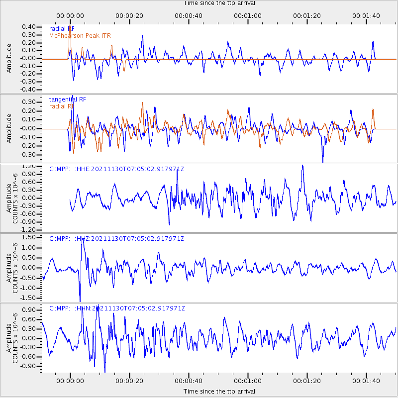
Signal To Noise
| Channel | StoN | STA | LTA |
| CI:MPP: :HHZ:20211130T07:05:02.917971Z | 2.5259864 | 7.0420805E-7 | 2.7878536E-7 |
| CI:MPP: :HHN:20211130T07:05:02.917971Z | 1.3902822 | 3.3324466E-7 | 2.3969568E-7 |
| CI:MPP: :HHE:20211130T07:05:02.917971Z | 1.6733668 | 3.7260932E-7 | 2.2267045E-7 |
| Arrivals |
| Ps | |
| PpPs | |
| PsPs/PpSs | |


