You are here: Home > Network List > G - GEOSCOPE Stations List
> Station MBO M'Bour, Senegal > Earthquake Result Viewer
MBO M'Bour, Senegal - Earthquake Result Viewer
| Earthquake location: |
Afghanistan-Tajikistan Bord Reg. |
| Earthquake latitude/longitude: |
37.0/71.4 |
| Earthquake time(UTC): |
2018/05/09 (129) 10:41:45 GMT |
| Earthquake Depth: |
112 km |
| Earthquake Magnitude: |
6.2 Mww |
| Earthquake Catalog/Contributor: |
NEIC PDE/us |
|
| Network: |
G GEOSCOPE |
| Station: |
MBO M'Bour, Senegal |
| Lat/Lon: |
14.39 N/16.95 W |
| Elevation: |
3.0 m |
|
| Distance: |
80.2 deg |
| Az: |
280.571 deg |
| Baz: |
54.316 deg |
| Ray Param: |
0.04820416 |
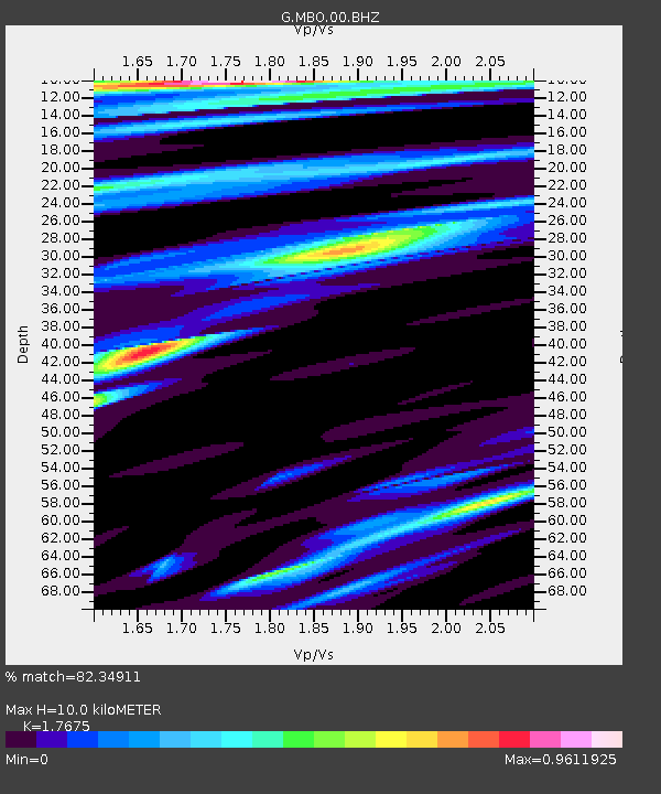
| Estimated Moho Depth: |
10.0 km |
| Estimated Crust Vp/Vs: |
1.77 |
| Assumed Crust Vp: |
5.55 km/s |
| Estimated Crust Vs: |
3.14 km/s |
| Estimated Crust Poisson's Ratio: |
0.26 |
|
| Radial Match: |
82.34911 % |
| Radial Bump: |
340 |
| Transverse Match: |
65.80928 % |
| Transverse Bump: |
400 |
| SOD ConfigId: |
2665671 |
| Insert Time: |
2018-05-23 10:43:09.517 +0000 |
| GWidth: |
2.5 |
| Max Bumps: |
400 |
| Tol: |
0.001 |
|
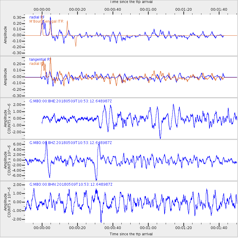
Signal To Noise
| Channel | StoN | STA | LTA |
| G:MBO:00:BHZ:20180509T10:53:12.648987Z | 5.883865 | 3.5315447E-6 | 6.0020835E-7 |
| G:MBO:00:BHN:20180509T10:53:12.648987Z | 0.65886784 | 4.165188E-7 | 6.321735E-7 |
| G:MBO:00:BHE:20180509T10:53:12.648987Z | 2.6310825 | 6.9993393E-7 | 2.6602507E-7 |
| Arrivals |
| Ps | 1.4 SECOND |
| PpPs | 4.9 SECOND |
| PsPs/PpSs | 6.3 SECOND |


