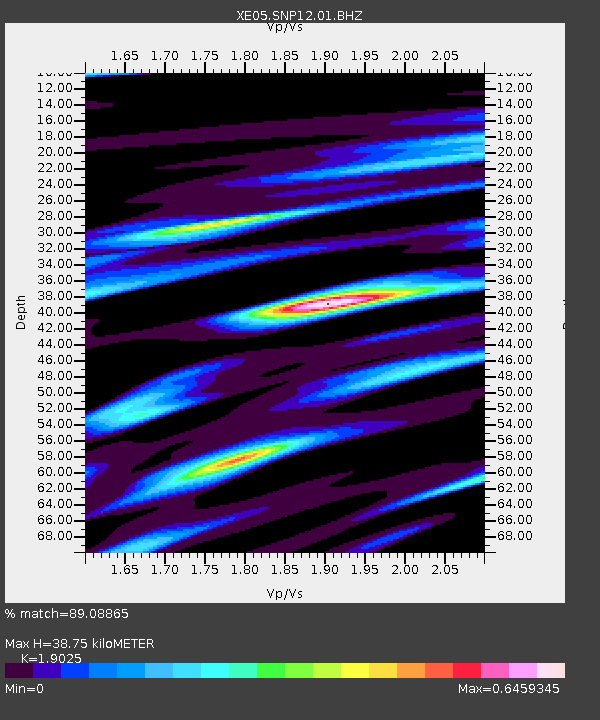
SNP12 SNP12 - Earthquake Result Viewer

Earthquake location: Fiji Islands Region
Earthquake latitude/longitude: -14.4/-177.3
Earthquake time(UTC): 2005/08/07 (219) 11:35:26 GMT
Earthquake Depth: 10 km
Earthquake Magnitude: 5.7 MB, 5.9 MS, 6.0 MW, 6.0 MW
Earthquake Catalog/Contributor: WHDF/NEIC
Network: XE Sierra Nevada EarthScope Project- EarthScope Flex Array
Station: SNP12 SNP12
Lat/Lon: 36.91 N/119.04 W
Elevation: 1284 m
Distance: 74.9 deg
Az: 44.902 deg
Baz: 238.565 deg
Ray Param: 0.052013434
Estimated Moho Depth: 38.75 km
Estimated Crust Vp/Vs: 1.90
Assumed Crust Vp: 6.291 km/s
Estimated Crust Vs: 3.307 km/s
Estimated Crust Poisson's Ratio: 0.31
Radial Match: 89.08865 %
Radial Bump: 400
Transverse Match: 74.100006 %
Transverse Bump: 400
SOD ConfigId: 268666
Insert Time: 2010-03-09 14:40:23.833 +0000
GWidth: 2.5
Max Bumps: 400
Tol: 0.001

Signal To Noise

ChannelStoNSTALTA
XE:SNP12:01:BHZ:20050807T11:46:35.790024Z3.140633.0988969E-79.8671194E-8
XE:SNP12:01:BHN:20050807T11:46:35.790024Z1.09964548.996041E-88.1808565E-8
XE:SNP12:01:BHE:20050807T11:46:35.790024Z2.48304681.313484E-75.2898077E-8
Arrivals
Ps5.7 SECOND
PpPs17 SECOND
PsPs/PpSs23 SECOND