You are here: Home > Network List > IW - Intermountain West Stations List
> Station MOOW Moose Ponds, Wyoming, USA > Earthquake Result Viewer
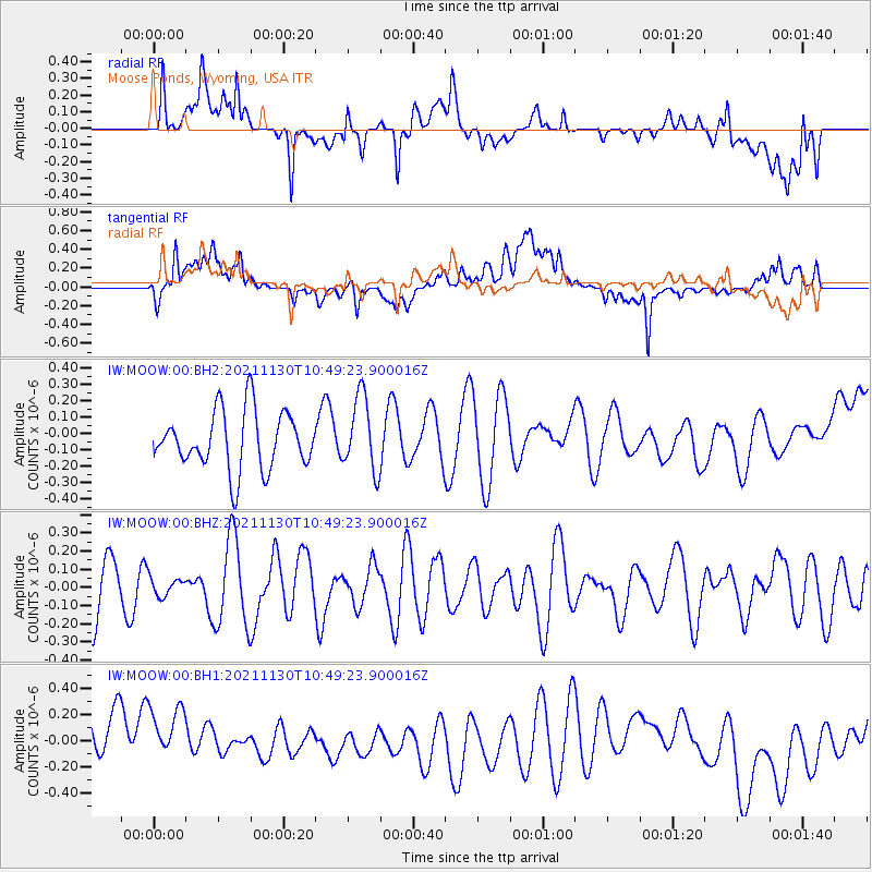
MOOW Moose Ponds, Wyoming, USA - Earthquake Result Viewer
*The percent match for this event was below the threshold and hence no stack was calculated.
| Earthquake location: |
New Ireland Region, P.N.G. |
| Earthquake latitude/longitude: |
-3.5/151.2 |
| Earthquake time(UTC): |
2021/11/30 (334) 10:36:18 GMT |
| Earthquake Depth: |
10 km |
| Earthquake Magnitude: |
6.0 mww |
| Earthquake Catalog/Contributor: |
NEIC PDE/us |
|
| Network: |
IW Intermountain West |
| Station: |
MOOW Moose Ponds, Wyoming, USA |
| Lat/Lon: |
43.75 N/110.74 W |
| Elevation: |
2128 m |
|
| Distance: |
98.3 deg |
| Az: |
46.47 deg |
| Baz: |
273.05 deg |
| Ray Param: |
$rayparam |
*The percent match for this event was below the threshold and hence was not used in the summary stack. |
|
| Radial Match: |
43.10091 % |
| Radial Bump: |
400 |
| Transverse Match: |
58.003345 % |
| Transverse Bump: |
400 |
| SOD ConfigId: |
26694651 |
| Insert Time: |
2021-12-14 10:45:08.348 +0000 |
| GWidth: |
2.5 |
| Max Bumps: |
400 |
| Tol: |
0.001 |
|
Signal To Noise
| Channel | StoN | STA | LTA |
| IW:MOOW:00:BHZ:20211130T10:49:23.900016Z | 0.21653175 | 5.0020365E-8 | 2.3100706E-7 |
| IW:MOOW:00:BH1:20211130T10:49:23.900016Z | 1.0349206 | 3.4991177E-7 | 3.3810497E-7 |
| IW:MOOW:00:BH2:20211130T10:49:23.900016Z | 1.2964404 | 2.2758476E-7 | 1.7554589E-7 |
| Arrivals |
| Ps | |
| PpPs | |
| PsPs/PpSs | |


