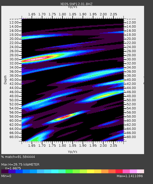
SNP12 SNP12 - Earthquake Result Viewer

Earthquake location: Tonga Islands
Earthquake latitude/longitude: -15.2/-173.6
Earthquake time(UTC): 2006/07/07 (188) 07:26:12 GMT
Earthquake Depth: 35 km
Earthquake Magnitude: 5.7 MB, 5.9 MS, 6.0 MW, 6.0 MW
Earthquake Catalog/Contributor: WHDF/NEIC
Network: XE Sierra Nevada EarthScope Project- EarthScope Flex Array
Station: SNP12 SNP12
Lat/Lon: 36.91 N/119.04 W
Elevation: 1284 m
Distance: 73.0 deg
Az: 43.069 deg
Baz: 235.328 deg
Ray Param: 0.05323396
Estimated Moho Depth: 29.75 km
Estimated Crust Vp/Vs: 1.67
Assumed Crust Vp: 6.291 km/s
Estimated Crust Vs: 3.773 km/s
Estimated Crust Poisson's Ratio: 0.22
Radial Match: 91.594444 %
Radial Bump: 400
Transverse Match: 80.48448 %
Transverse Bump: 400
SOD ConfigId: 268666
Insert Time: 2010-03-09 14:41:04.687 +0000
GWidth: 2.5
Max Bumps: 400
Tol: 0.001

Signal To Noise

ChannelStoNSTALTA
XE:SNP12:01:BHZ:20060707T07:37:07.79001Z6.5634275.0473255E-77.690077E-8
XE:SNP12:01:BHN:20060707T07:37:07.79001Z4.3102321.708662E-73.9641993E-8
XE:SNP12:01:BHE:20060707T07:37:07.79001Z4.6531442.0740704E-74.4573525E-8
Arrivals
Ps3.3 SECOND
PpPs12 SECOND
PsPs/PpSs15 SECOND