You are here: Home > Network List > KR - Kyrgyz Digital Network Stations List
> Station SALK Salom-Alik, Kyrgyzstan > Earthquake Result Viewer
SALK Salom-Alik, Kyrgyzstan - Earthquake Result Viewer
| Earthquake location: |
New Ireland Region, P.N.G. |
| Earthquake latitude/longitude: |
-3.5/151.2 |
| Earthquake time(UTC): |
2021/11/30 (334) 10:36:18 GMT |
| Earthquake Depth: |
10 km |
| Earthquake Magnitude: |
6.0 mww |
| Earthquake Catalog/Contributor: |
NEIC PDE/us |
|
| Network: |
KR Kyrgyz Digital Network |
| Station: |
SALK Salom-Alik, Kyrgyzstan |
| Lat/Lon: |
40.88 N/73.82 E |
| Elevation: |
1672 m |
|
| Distance: |
82.8 deg |
| Az: |
311.778 deg |
| Baz: |
100.974 deg |
| Ray Param: |
0.046672735 |
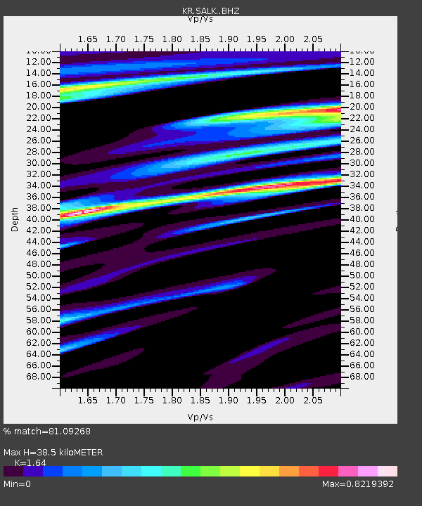
| Estimated Moho Depth: |
38.5 km |
| Estimated Crust Vp/Vs: |
1.64 |
| Assumed Crust Vp: |
6.306 km/s |
| Estimated Crust Vs: |
3.845 km/s |
| Estimated Crust Poisson's Ratio: |
0.20 |
|
| Radial Match: |
81.09268 % |
| Radial Bump: |
400 |
| Transverse Match: |
72.40478 % |
| Transverse Bump: |
400 |
| SOD ConfigId: |
26694651 |
| Insert Time: |
2021-12-14 10:45:34.382 +0000 |
| GWidth: |
2.5 |
| Max Bumps: |
400 |
| Tol: |
0.001 |
|

Signal To Noise
| Channel | StoN | STA | LTA |
| KR:SALK: :BHZ:20211130T10:48:10.799979Z | 1.5492959 | 4.4732243E-8 | 2.8872625E-8 |
| KR:SALK: :BHN:20211130T10:48:10.799979Z | 0.81772786 | 2.8112512E-7 | 3.4378814E-7 |
| KR:SALK: :BHE:20211130T10:48:10.799979Z | 1.4947388 | 1.05707855E-7 | 7.071995E-8 |
| Arrivals |
| Ps | 4.0 SECOND |
| PpPs | 16 SECOND |
| PsPs/PpSs | 20 SECOND |


