You are here: Home > Network List > PF - Volcanologic Network of Piton de Fournaise-OVPF Stations List
> Station HIM cratere Himiltrude > Earthquake Result Viewer
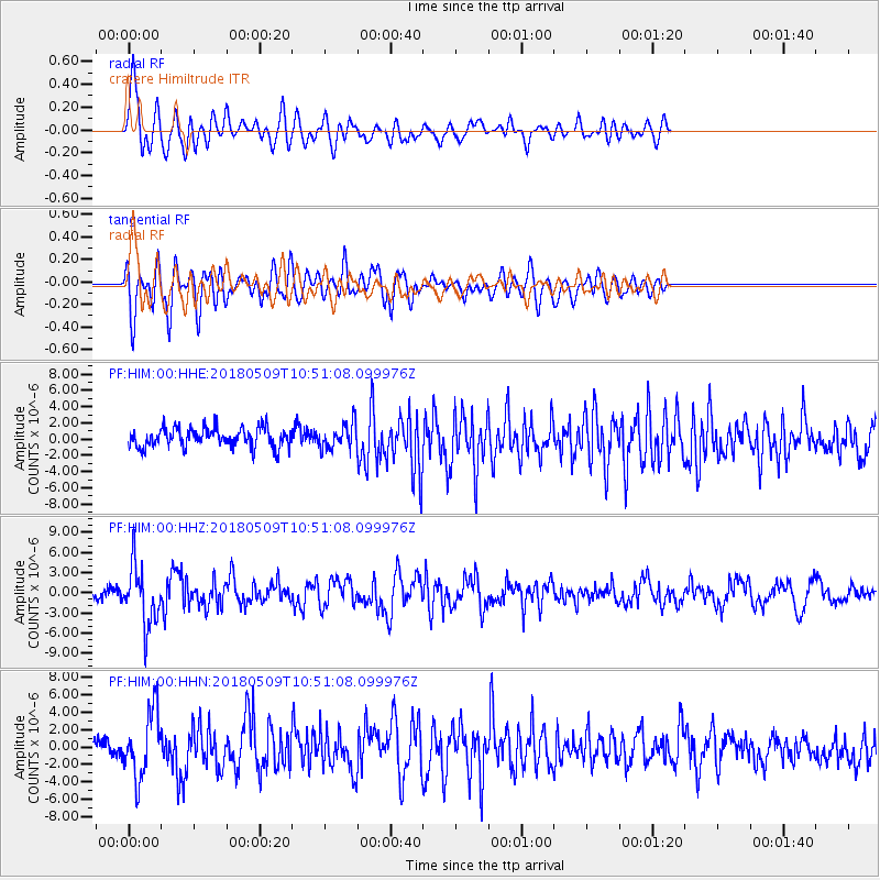
HIM cratere Himiltrude - Earthquake Result Viewer
*The percent match for this event was below the threshold and hence no stack was calculated.
| Earthquake location: |
Afghanistan-Tajikistan Bord Reg. |
| Earthquake latitude/longitude: |
37.0/71.4 |
| Earthquake time(UTC): |
2018/05/09 (129) 10:41:45 GMT |
| Earthquake Depth: |
112 km |
| Earthquake Magnitude: |
6.2 Mww |
| Earthquake Catalog/Contributor: |
NEIC PDE/us |
|
| Network: |
PF Volcanologic Network of Piton de Fournaise-OVPF |
| Station: |
HIM cratere Himiltrude |
| Lat/Lon: |
21.21 S/55.72 E |
| Elevation: |
1958 m |
|
| Distance: |
59.7 deg |
| Az: |
196.94 deg |
| Baz: |
14.48 deg |
| Ray Param: |
$rayparam |
*The percent match for this event was below the threshold and hence was not used in the summary stack. |
|
| Radial Match: |
65.58032 % |
| Radial Bump: |
400 |
| Transverse Match: |
50.30689 % |
| Transverse Bump: |
400 |
| SOD ConfigId: |
2665671 |
| Insert Time: |
2018-05-23 10:45:07.782 +0000 |
| GWidth: |
2.5 |
| Max Bumps: |
400 |
| Tol: |
0.001 |
|
Signal To Noise
| Channel | StoN | STA | LTA |
| PF:HIM:00:HHZ:20180509T10:51:08.099976Z | 5.3128457 | 4.314781E-6 | 8.1214125E-7 |
| PF:HIM:00:HHN:20180509T10:51:08.099976Z | 3.0083601 | 3.8070705E-6 | 1.2654968E-6 |
| PF:HIM:00:HHE:20180509T10:51:08.099976Z | 1.3036792 | 1.5583357E-6 | 1.1953367E-6 |
| Arrivals |
| Ps | |
| PpPs | |
| PsPs/PpSs | |


