You are here: Home > Network List > IW - Intermountain West Stations List
> Station MOOW Moose Ponds, Wyoming, USA > Earthquake Result Viewer
MOOW Moose Ponds, Wyoming, USA - Earthquake Result Viewer
*The percent match for this event was below the threshold and hence no stack was calculated.
| Earthquake location: |
Easter Island Region |
| Earthquake latitude/longitude: |
-28.6/-112.3 |
| Earthquake time(UTC): |
2021/12/03 (337) 04:40:04 GMT |
| Earthquake Depth: |
10 km |
| Earthquake Magnitude: |
6.2 mww |
| Earthquake Catalog/Contributor: |
NEIC PDE/us |
|
| Network: |
IW Intermountain West |
| Station: |
MOOW Moose Ponds, Wyoming, USA |
| Lat/Lon: |
43.75 N/110.74 W |
| Elevation: |
2128 m |
|
| Distance: |
72.0 deg |
| Az: |
1.155 deg |
| Baz: |
181.401 deg |
| Ray Param: |
$rayparam |
*The percent match for this event was below the threshold and hence was not used in the summary stack. |
|
| Radial Match: |
37.830112 % |
| Radial Bump: |
400 |
| Transverse Match: |
43.06005 % |
| Transverse Bump: |
400 |
| SOD ConfigId: |
26694651 |
| Insert Time: |
2021-12-17 04:53:04.465 +0000 |
| GWidth: |
2.5 |
| Max Bumps: |
400 |
| Tol: |
0.001 |
|
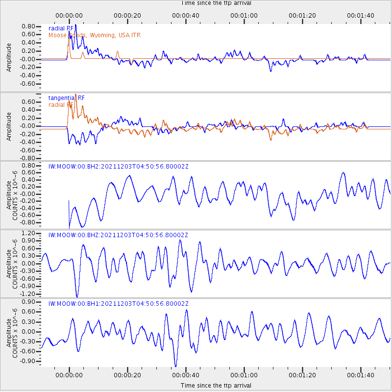
Signal To Noise
| Channel | StoN | STA | LTA |
| IW:MOOW:00:BHZ:20211203T04:50:56.80002Z | 2.533505 | 6.1555374E-7 | 2.4296529E-7 |
| IW:MOOW:00:BH1:20211203T04:50:56.80002Z | 1.007513 | 5.444561E-7 | 5.4039606E-7 |
| IW:MOOW:00:BH2:20211203T04:50:56.80002Z | 0.6271458 | 2.5913803E-7 | 4.132022E-7 |
| Arrivals |
| Ps | |
| PpPs | |
| PsPs/PpSs | |


