You are here: Home > Network List > NN - Western Great Basin/Eastern Sierra Nevada Stations List
> Station PRN Pahroc Range, Nevada. (GPS 12/04/2000) w84 > Earthquake Result Viewer
PRN Pahroc Range, Nevada. (GPS 12/04/2000) w84 - Earthquake Result Viewer
| Earthquake location: |
Easter Island Region |
| Earthquake latitude/longitude: |
-28.6/-112.3 |
| Earthquake time(UTC): |
2021/12/03 (337) 04:40:04 GMT |
| Earthquake Depth: |
10 km |
| Earthquake Magnitude: |
6.2 mww |
| Earthquake Catalog/Contributor: |
NEIC PDE/us |
|
| Network: |
NN Western Great Basin/Eastern Sierra Nevada |
| Station: |
PRN Pahroc Range, Nevada. (GPS 12/04/2000) w84 |
| Lat/Lon: |
37.41 N/115.05 W |
| Elevation: |
1464 m |
|
| Distance: |
65.7 deg |
| Az: |
357.563 deg |
| Baz: |
177.31 deg |
| Ray Param: |
0.05806397 |
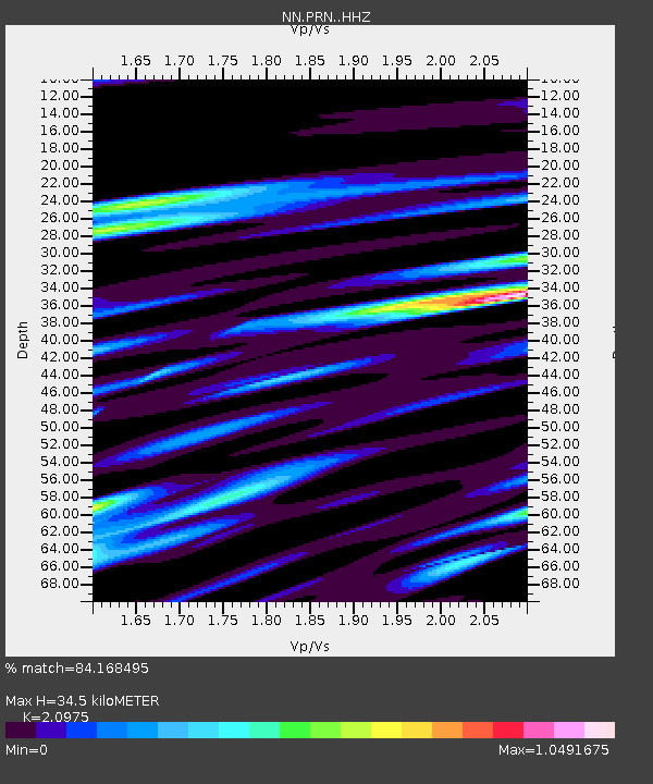
| Estimated Moho Depth: |
34.5 km |
| Estimated Crust Vp/Vs: |
2.10 |
| Assumed Crust Vp: |
6.276 km/s |
| Estimated Crust Vs: |
2.992 km/s |
| Estimated Crust Poisson's Ratio: |
0.35 |
|
| Radial Match: |
84.168495 % |
| Radial Bump: |
328 |
| Transverse Match: |
72.77359 % |
| Transverse Bump: |
361 |
| SOD ConfigId: |
26694651 |
| Insert Time: |
2021-12-17 04:56:36.636 +0000 |
| GWidth: |
2.5 |
| Max Bumps: |
400 |
| Tol: |
0.001 |
|

Signal To Noise
| Channel | StoN | STA | LTA |
| NN:PRN: :HHZ:20211203T04:50:17.720002Z | 3.3517165 | 7.7108865E-7 | 2.3005784E-7 |
| NN:PRN: :HHN:20211203T04:50:17.720002Z | 2.435949 | 3.3170335E-7 | 1.3617007E-7 |
| NN:PRN: :HHE:20211203T04:50:17.720002Z | 0.5967449 | 1.08991905E-7 | 1.8264404E-7 |
| Arrivals |
| Ps | 6.2 SECOND |
| PpPs | 16 SECOND |
| PsPs/PpSs | 23 SECOND |


